Presteigne and Norton, a town and neighboring village in the Welsh county of Powys, have been announced as Wales’ first “dark sky community” by DarkSky International.
Lights will be dimmed or turned off earlier in order to lower light pollution in the area, allowing residents to get a clearer view of the night sky, reported BBC News.
“The Community has worked tenaciously over the last six years to highlight the benefits of becoming a dark sky community,” said Leigh-Harling Bowen, leader of the Presteigne & Norton Dark Skies Community, a press release from DarkSky International said. “These benefits include an investment in the use of efficient, low-energy ‘dark skies’ streetlights that have reduced our impact on the environment. This change has resulted in a reduction in greenhouse gas emissions, along with a beneficial effect on wildlife, especially night-flying insects, birds, and bats. The consequential reduction in light pollution has also enabled us to see the glory of the night sky clearly, a legacy that our children and grandchildren will continue to enjoy.”
Powys is the largest county in Wales, and the dark sky area covers about 15 square miles. Presteigne and Norton have a total population of 2,700.
Lighting tests were conducted to make sure the towns were in compliance with Dark Sky Community requirements, and feedback from residents was taken during the project.
The area’s 380 lighting columns were refitted with 2200K LED lights. After midnight, 40 percent were programmed to turn off, with the remainder set to switch to half their intensity. This not only lowers the brightness of the lights, but extends their longevity while reducing energy usage.
“[W]e are making sure that lights don’t adversely affect bat routes or otter feeding areas and specifically use a colour temperature of 2200K for our lanterns so they are nature-friendly and dark sky compliant,” said Cllr Jackie Charlton, Powys County Council cabinet member for a greener Powys, in the press release.
The dark sky project has lowered the yearly carbon emissions of the area by nearly five tons.
“The approach taken to retrofit lighting using adaptive technology is unique among Dark Sky Places and will serve as an excellent example of how communities can use lighting technology to improve safety and energy efficiency. This work signals an important shift in community-level lighting design, showing that being dark sky-friendly doesn’t mean turning out the lights,” said Amber Harrison, program manager of Dark Sky Places, in the press release.
Because of the project’s success, authorities are considering similar plans across Wales.
“We are delighted by the outcome of Presteigne’s and Norton’s application to Dark Sky International to become a Dark Sky Community! Without the dedicated and coordinated support of both Presteigne and Norton Town Council and Powys County Council, it would never have happened,” Bowen said.
Jay Tate, an observatory worker at the nearby Spaceguard Centre, said not everyone was sure about the project at first.
“There was a certain amount of resistance at the beginning because it’s new… there was a bit of concern about whether it was safe,” Tate said, as BBC News reported. “People thought we’d just switch the lights off, but once the situation’s explained… everybody’s more than happy.”
Part of what Tate does is scan the night sky for comets and asteroids, and he said the new changes have made his job “much easier.”
Presteigne and Norton have plans to improve private, festive and industrial lighting, as well as organize community events so everyone can enjoy the dark skies and their wonders even more, DarkSky International said.
Charlton expressed hope that the benefits of dark skies would be implemented by other local communities.
“For the layperson, for anyone walking in the community, you probably don’t actually notice the difference,” said Mayor of Presteigne and Norton Beverley Baynham, as reported by BBC News. “It’s just lit in a more intelligent way… so there’s no concerns, no worries about safety. It’s better for the light pollution, it’s better for the environment, but it’s also better for our community.”
An enormous ancient civilization has been discovered in Ecuador’s Upano Valley, hidden for millenia by rainforest vegetation, reported the BBC. The existence of the intricately laid development rewrites previous assumptions about the human history of the Amazon.
The settlement — located beneath a volcano — has a web of canals and roads connecting homes and plazas. The volcano’s rich minerals meant fertile soil for the agricultural community, but may have also been the cause of its demise.
“This is older than any other site we know in the Amazon. We have a Eurocentric view of civilisation, but this shows we have to change our idea about what is culture and civilisation,” said professor Stéphen Rostain, leader of the study and director of investigation at France’s National Centre for Scientific Research, as the BBC reported.
“Lidar” laser mapping technology showed the civilization is a lattice of interconnected villages that are a minimum of 2,500 years old, reported Science. That’s more than a thousand years older than other previously uncovered Amazonian societies of similar complexity.
“It changes the way we see Amazonian cultures. Most people picture small groups, probably naked, living in huts and clearing land – this shows ancient people lived in complicated urban societies,” said Antoine Dorison, co-author of the study, according to the BBC.
Archaeologists said people occupied the settlement for as long as a thousand years, but it is hard to estimate the number of residents — anywhere from in the 10 to 100 thousands, scientists say.
“It was a lost valley of cities,” Rostain said, as The Guardian reported. “It’s incredible.”
The archaeologists surveyed an area of 116 square miles from a plane with laser sensors, as well as conducted ground excavations to explore the city’s remnants underneath thick foliage, reported the BBC.
They discovered 6,000 platforms of approximately 66 by 33 feet and six-and-a-half to nearly 10 feet high. The platforms surrounded a plaza in clusters of three to six together. The plaza had another central platform. Scientists think some of the structures — which were carved into hillsides — were used for ceremonies.
Ditches at the entrances of the cities indicated there may have been some outside threats.
Ten smaller settlements and five larger ones were found, Science reported. They were surrounded by agricultural terraces built into the hillside that had been used to plant manioc, sweet potatoes and corn, evidence of which had been found in previous excavations. There were streets between neighborhoods and houses, as well as roads connecting cities.
“We’re talking about urbanism,” said Fernando Mejía, a Pontifical Catholic University of Ecuador archaeologist who is one of the co-authors of the research, in Science.
Rostain and his team first started excavations in the Upano Valley almost three decades ago, focusing on the Kilamope and Sangay, two of the larger settlements. Along with central plazas, they found jugs with remnants of chicha — a traditional beer made from maize — and painted pottery. However, Rostain said he “didn’t have a complete overview of the region” at the time.
The authors of the study said the vastness of the civilization challenges that of Classic Mayan “garden cities,” but “is just the tip of the iceberg,” according to Mejía.
Scientists are just beginning to discover the social and cultural complexity and structure of the ancient civilizations.
“We say ‘Amazonia,’ but we should say ‘Amazonias,’” because of the area’s ancient cultural complexity, Rostain observed.
The study, “Two thousand years of garden urbanism in the Upper Amazon,” was published in Science.
“It’s amazing that we can still make these kinds of discoveries on our planet and find new complex cultures in the 21st century,” said Thomas Garrison, a University of Texas at Austin geographer and archaeologist who was not part of the study, as reported by Science.
A new study has found that much of the land needed to preserve biodiversity and maintain well-being for humans is lacking protections that would prevent development.
The study, published in the journal Nature Communications, found that about half of all land on Earth needs sustainable management to protect over 26,000 terrestrial vertebrate species. Further, the research reveals that just 18% of this land needed to meet global biodiversity targets is properly protected.
“We face enormous challenges,” Amanda Rodewald, senior author and the Garvin Professor and senior director of the Center for Avian Population Studies at Cornell University’s Lab of Ornithology, said in a statement. “With limited resources available to address climate change, biodiversity loss, poverty and water insecurity, we must be strategic and find ways to tackle more than one challenge at a time.”
The research maps out some of the most critical areas on earth for both biodiversity and for providing nature’s benefits to humans. The study authors noted that in addition to increasing conservation measures, these measures and climate targets should include more information on how nature and biodiversity benefit humanity.
“Biodiversity, climate and sustainable development cannot be considered in isolation,” said lead author Rachel Neugarten, lead author of the study and a doctoral student at Cornell University’s Lab of Ornithology. “We must also factor in nature’s contributions to human well-being, including clean water, carbon storage, crop pollination, flood mitigation, coastal protection and more.”
Of the most critical areas on Earth for biodiversity, about 37% are also valued for development opportunities, according to the study. Conflict could arise over these land areas, which could be developed for agriculture, energy (both renewable and non-renewable) and mining. These areas are also at risk from urban development projects.
The authors wrote in the study that while renewable energy projects are necessary to curb the worst impacts of climate change, these types of projects will need to be carefully planned and implemented in a way that minimally disrupts areas that need more conservation protections.
“If designed carefully, renewable energy development can be compatible with biodiversity conservation and ecosystem services to people,” Neugarten said. “Examples of this include livestock grazing under wind farms or cultivating native pollinator gardens under solar panels. But there’s a real risk that achieving renewable energy goals could conflict with nature conservation goals without careful planning.”
In 1968, the U.S. government passed the Wild and Scenic Rivers Act, designating the first eight free-flowing rivers as protected — the Rio Grande, Rogue, Clearwater, St. Croix, Eleven Point, Idaho’s Salmon and Wolf Rivers.
Today, there are 226 wild and scenic rivers and streams covering more than 13,4000 miles in the national Wild and Scenic Rivers System. In partnership with the public, the U.S. Forest Service works to protect the water quality and free flowing nature of these waterways, as well as safeguard them from development, overuse and other destructive impacts.
Here are some of the country’s most spectacular wild and scenic rivers you might want to explore on your next outdoor adventure.
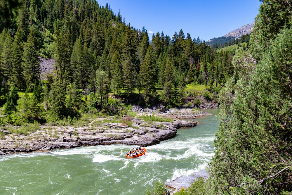
Snake River, Wyoming, Idaho & Washington
Whitewater rafting on the Snake River near Jackson, Wyoming. christiannafzger / iStock / Getty Images Plus
Designated as a Wild and Scenic River in 2009, the Snake River flows 1,078 miles through the mountains, valleys and grasslands of Washington, Idaho and Wyoming, where it originates. It flows through Yellowstone National Park, as well as the cities of Idaho Falls, Twin Falls, Boise, Jackson and Lewiston, with spectacular views from the Hells Canyon gorge.
“While cruising my motorcycle down through the Hell’s Canyon area of the Snake River on a hot summer day, I literally felt like I was being poured into one of the most memorable and vivid displays of nature’s beauty that I can remember. The canyon walls, steep elevation changes and the winding road itself made for a magnificent and memorable experience, and I remember thinking to myself as I roared down the road, ‘This is exactly why I ride,’” Harley rider and nature enthusiast Patrick Roat told EcoWatch.
The Snake River empties into the Columbia River — which forms the border of Oregon and Washington — and is its largest tributary. While it was once the spawning grounds of over two million wild steelhead and salmon, these species are now threatened or extinct in the Snake River and its tributaries. Their biggest threat are four dams — built in the 1960s and ’70s — upstream of the lower 48 states’ biggest freshwater salmon habitat.
A federal court-ordered review was done by the government in 2016 of whether to keep the outdated dams in place, and the decision was to keep them intact.
“As scientists, tribes, and fishermen all warned, these four dams decimated the Snake River’s salmon and steelhead. The four dams transformed the Lower Snake River into a series of warm, shallow lakes where predators, dam turbines, and hot water kill too many migrating salmon,” Columbia Riverkeeper wrote.
The lives of Snake River steelhead and salmon begin in the mountains of Washington, Oregon and Idaho, before the young fish head to the ocean. They spend several years there before traveling the more than 900 miles to the Salmon River’s headwaters in Idaho. There they spawn at the highest elevations of any steelhead or salmon on Earth.
“The Snake cuts through my hometown of Idaho Falls. I love that river and the falls — once natural but now a source of hydroelectricity. I remember Terry Tempest Williams saying something about how the kind of water we grow up around profoundly affects us, imprints itself upon us. She was talking about the Great Salt Lake, but I was thinking while she was talking about my Snake. I grew up admiring that river but also fearing her, like a wild and strong mother. She mesmerized me and terrified me. On the surface the Snake is so seemingly placid, but she’s also fast. And underneath, there is so much happening because of the rocky river bottom, the pull of the undertows,” writer and teacher Carissa Neff told EcoWatch.
When visiting the Snake River region, you can expect to see plenty of wildlife, including moose, elk, pronghorn, mountain goats, American beavers, North American river otters, marmots and coyotes. Approximately 300 bird species grace the skies of the area around the river, from eagles and osprey to the great gray owl, peregrine falcon, calliope hummingbird and trumpeter swan.
There are a variety of campgrounds along the river, including the Miracle and Banbury Hot Springs, which feature geothermal hot springs, a massage center and kayak rentals.
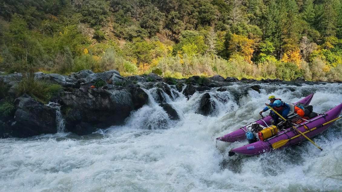
Rogue River, Oregon
Juliana Statius Muller rowing a purple whitewater cataraft on the Rogue River. John Jones
At 215 miles long, the lower portion of Oregon’s Rogue River was one of the original Wild and Scenic Rivers Act designations of 1968. The wild and scenic Lower Rogue River runs 84 miles from the Applegate River mouth — about six miles from Grants Pass — to the Lobster Creek Bridge.
The Rogue originates in the Cascades on Mt. Mazama’s western slopes — not far from Crater Lake National Park — before emptying into the Pacific at Gold Beach. The river is famous for its whitewater rafting and salmon and steelhead runs.
A war between white settlers who had come to the region during the Gold Rush and members of the Takelma, Athabaskan and Oregon Shasta Native American Tribes resulted in Tribal members being forced from their land onto reservations in 1856. Their descendants are members of today’s Confederated Tribes of Grand Ronde and Siletz.
In addition to Chinook and coho salmon, green sturgeon, steelhead and cutthroat trout, the Rogue is home to Roosevelt elk, black bears, otters, black-tailed deer, American beaver, ospreys, green herons, great blue herons, red-winged blackbirds, Steller’s jays, woodpeckers, Canada geese, kingfishers and bald eagles.
Among the many hiking options along the river, the 40-mile Rogue River National Recreation Trail will take you along its wild and scenic section from Grave Creek to Big Bend. Along the trail you will have opportunities to encounter spectacular waterfalls, wildlife, wildflowers and historical sites.
Other trails along the Rogue River include the 1.1-mile Redwood Nature Trail loop that begins near Brookings, Oregon; the 9.5-mile Wagner Butte Trail — an out-and-back hike near Ashland; and the moderately difficult 0.8-mile out-and-back National Falls Creek Trail near Prospect, Oregon.
The Wild Rogue Wilderness canyon that surrounds the river gives watershed protection for its wild and scenic portion, which features vertical cliffs with sharp-edged ridges. Here you’ll find striking geological formations, old-growth forests and pristine meadows with wildflowers like redwood sorrel, wild ginger, mock orange and red flowering currant.
The Rogue River in Oregon. alacatr / iStock / Getty Images Plus
Large cedar, Shasta red fir and white fir trees hug the upper portion of the river, while broadleaf evergreens, a variety of conifers and deciduous trees grow further downstream. The whole Rogue River canyon is populated by enormous Douglas fir, ponderosa pine, Jeffrey pine, oak, manzanita and madrone trees.
Another of the many wonderful things about the wild and scenic section of the Rogue River is that — in addition to many unmarked, established campsites — camping is allowed anywhere along the river that is “physically suitable for your group,” according to the Bureau of Land Management.
“Around the second half of October each year, the Wild and Scenic section of the Rogue River might include some fun Halloween surprises – in the form of cute miniature pumpkins. The pumpkins start appearing on mid-channel rocks on both sides of the river between Alameda campground and Foster Bar. I have yet to see who places the pumpkins, but it is really fun to see a little pumpkin on a rock in the middle of a rapid, right where you need to make a move with your oars,” adventurer Sarah Strock told EcoWatch.
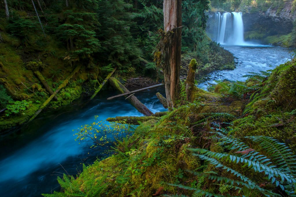
McKenzie River, Oregon
The McKenzie River in Willamette National Forest, Oregon. Prisma by Dukas / Universal Images Group via Getty Images
My favorite river in Oregon, the stunning McKenzie River was given wild and scenic status in 1988. It originates in the Central Cascade Mountains at Clear Lake, flowing southwest through Willamette National Forest.
The cool, clear McKenzie runs beneath cedar, pine and maple trees. And on sunny days, the dappled river flows over the millennia of cobbles and hardened lava of the ancient riverbed.
The upper portion of the McKenzie River Basin was shaped by volcanic activity and lava flows that formed waterfalls, pools and whitewater. Clear Lake was carved out by a basaltic lava flow, and lava flows also created the river’s Koosah and Sahalie waterfalls. These aspects of the river provide magnificent views for hiking and kayaking, as well as extraordinary whitewater rafting.
The McKenzie is home to a host of fish species, including wild spring Chinook salmon and native rainbow, cutthroat and bull trout.
The McKenzie River National Recreation Trail offers 26 miles of spectacular “easy” level hiking for all ages and recreational opportunities along the river, including 11 trailheads, campgrounds and views of Tamolitch, Koosah and Sahalie Falls.
Close to the McKenzie River National Recreation Trail is the McKenzie Bridge Campground, which offers 20 campsites tucked beneath western red cedar and Douglas-fir trees, all with river access.
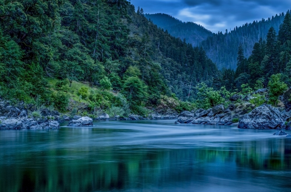
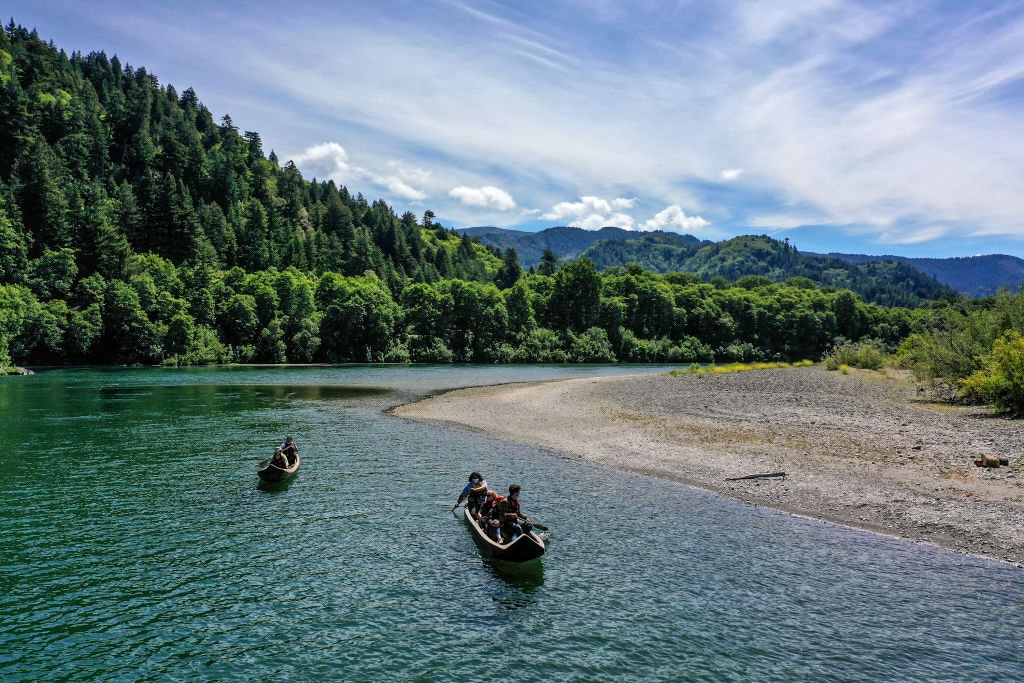
Klamath River, Oregon & California
Tourists paddle along the Klamath River in traditional canoes handcrafted from redwood trees. Robert Gauthier / Los Angeles Times
Another magical Western U.S. waterway — added to the National Wild & Scenic Rivers System in 1981 — is the Klamath River. The 257-mile blue-green river originates on a plateau in South-Central Oregon, east of the Cascades. Underground springs swell from cracks in the volcanic rock, feeding the river. Other sources include the Williamson, Sprague, Wood and Sycan rivers, Upper Klamath Lake and the region’s wetlands and marshes.
The Klamath River Basin stretches through parts of six Oregon and California counties and has been the territory of several Native American Tribes — including the Shasta, Hupa, Klamath, Yurok and Karuk — for thousands of years. The river’s once-plentiful salmon were harvested by the Tribes sustainably using weirs.
There are currently dams on the Klamath River that block salmon habitat and create water quality issues, but they are scheduled to be removed, and one has already been taken down. In addition to coho and Chinook salmon, the glittering river supports populations of steelhead trout whose populations have been cut by approximately 95 percent.
“Four dams along the Klamath River, which runs from Oregon into northwestern California, are scheduled to be removed in 2023 and 2024 – Copco No. 1, Copco No. 2, Iron Gate, and JC Boyle. These dams total 400 vertical feet and choke fish passage along hundreds of miles of waterways, making this a historic opportunity and one of the largest dam removal projects to date. And construction has started!” the American Rivers said.
Some of the more than 430 species of wildlife — including 263 types of birds — who call the Klamath River Basin home include elk, antelope, pronghorn, black bears, cougars, mule deer and river otters. The U.S. Fish and Wildlife Service, as well as the states of California and Oregon, have designated dozens of these species “at risk” or “of concern” due to shrinking populations and habitat loss. As the largest freshwater wetlands found west of the Mississippi, the basin is essential for the region’s fish and wildlife.
The Klamath River rushes through several wilderness areas and national forests on its journey west and south, including Klamath National Forest in Oregon and Six Rivers National Forest in California.
This wild and scenic river has hundreds of trail miles to hike — including the nine-mile Klamath River Trail loop and the Pacific Crest Trail, which crosses the river near the town of Seiad Valley, California — as well as five wilderness areas nearby.
Coastal Georgia regulators want to change a rule designed to protect the state’s marshes, which serve as a buffer against storms and rising sea levels and a vital part of the coastal ecosystem. But advocates say the seemingly small change points to a need for a broader review of marsh protections.
The state passed a law to protect coastal salt marsh half a century ago, which means that now, though Georgia has just 100 miles of coastline, it’s home to half a million acres of salt marsh — the second-largest amount of salt marsh in the country and a third of the marshes on the East Coast. Those marshes absorb the power of strong storm surges and capture carbon in their grasses and mud.
So coastal advocates are especially sensitive to changes in the state’s marsh law — concerned that modifications to allow more development could erode protections, leading to actual erosion of the coastline itself.
But at a public meeting last week on the proposed change, state officials tried to assuage concerns.
“This amendment is not intended to roll back any marsh protections,” said Jill Andrews, chief of coastal management for the state’s Coastal Resources Division, or CRD. “It will not change a thing within the actual Coastal Marshlands Protection Act itself. It is not intended, nor will it, fast-track bulkheads or shoreline hardening.”
Salt marshes exist along much of the country’s coastline, from New England to Florida, along the Gulf, and on the West Coast — but many have been degraded or destroyed by development, industry, and other human activities. Multimillion-dollar efforts are underway in many of those places to restore marsh habitat. In the Southeast, coastal managers have launched a new regional initiative aimed at restoring and better protecting the marshes in the Carolinas, Georgia, and Florida.
In Georgia, most structures built in the state’s well-preserved coastal marshes need a permit under the marsh protection law, also known as CMPA. That goes for large docks, marinas, or a length of bulkhead — a kind of small wall along the waterfront designed to prevent shoreline erosion of someone’s backyard.
Those projects also get a 50-foot buffer, a zone of dry land where no building or paving is allowed because it might affect the marsh. The buffer line is measured from the part of the project that’s farthest from the marsh, known to regulators as the “upland component.” For a marina, that might include buildings for dry dock boat storage, bathrooms, or a shop. For shoreline stabilization like a bulkhead, the upland component might only be underground anchors that hold the structure in place.
The buffer rule is what CRD wants to change, because the agency says it can be a problem for smaller projects.
At the public meeting last week, Andrews explained that the buffer for a bulkhead on a residential property might run through the house. In an example she showed, the buffer encompasses most of a home’s backyard. That means the homeowner couldn’t build a shed, fire pit, or swing set without special permission from the CRD, which the agency says creates a burden both for homeowners and for the agency.
So the agency is proposing a rule change to exempt small projects from the upland component buffer requirement. Andrews and other CRD officials at the meeting stressed that shoreline stabilization projects and anything else built in the marsh will still need CMPA permits, even if the project is exempted from the buffer rule.
But critics said it’s time for a more comprehensive review. Instead of the rule change, several environmental groups are calling for a stakeholder committee to take a holistic look at how projects are approved and what rules protect the marsh.
Speaking at the meeting, Bill Sapp of the Southern Environmental Law Center said bulkheads are particularly worrisome because while building them can stabilize a shoreline in the short term, they can do long-term damage to the marsh. And though each project is small, Sapp said they can add up.
“There are going to be more and more bulkheads built along the Georgia coast over the years as the sea level rises,” he said.
And advocates said this permitting question points to a bigger concern: development too close to the marsh.
Josiah Watts grew up on Sapelo Island and now works for environmental group One Hundred Miles. He told attendees at the meeting the marsh is sacred as well as a protective buffer for the coast, and the state should rethink allowing building close to it.
“When we’re talking about bulkheads, we’re also talking about development,” he said. “That means that there is construction and building near these spaces on the coast and the marsh.”
The Coastal Resources Division is accepting public comments about the proposed change to marsh buffers until January 19.
As sea levels rise by multiple feet in the coming decades, communities along the coastal United States will face increasingly frequent flooding from high tides and tropical storms. Thousands of homes will become uninhabitable or disappear underwater altogether. For many in these communities, these risks are poised to drive migration away from places like New Orleans, Louisiana, and Miami, Florida — and toward inland areas that face less danger from flooding.
This migration won’t happen in a uniform manner, because migration never does. In large part this is because young adults move around much more than elderly people, since the former have better job prospects. It’s likely that this time-tested trend will hold true as Americans migrate away from climate disasters: The phenomenon has already been observed in places like New Orleans, where elderly residents were less likely to evacuate during Hurricane Katrina in 2005, and in Puerto Rico, where the median age has jumped since 2017’s Hurricane Maria, as young people leave the U.S. territory for the mainland states.
A new paper published in the prestigious Proceedings of the National Academy of Sciences offers a glimpse at the shape and scale of this demographic shift as climate change accelerates. Using sea-level rise models and migration data gleaned from the latest U.S. Census, the paper projects that outmigration from coastal areas could increase the median age in those places by as much as 10 years over the course of this century. That’s almost as much as the difference between the median age in the United States and the median age in Japan, which is among the world’s most elderly countries.
Climate-driven migration promises a generational realignment of U.S. states, as coastal parts of Florida and Georgia grow older and receiving states such as Texas and Tennessee see an influx of young people. It could also create a vicious cycle of decline in coastal communities, as investors and laborers relocate from vulnerable coasts to inland areas — and in doing so incentivize more and more working-age adults to follow in their footsteps.
“When we’re thinking about the effect of climate migration on population change, we have to think beyond just the migrants themselves and start thinking about the second order effects,” said Mathew Hauer, a professor of geography at Florida State University and the lead author of the paper.
In his previousresearch, Hauer has produced some of the only nationwide climate migration projections for the United States. His previous papers have modeled a slow shift away from coastlines and toward inland southern cities such as Atlanta, Georgia, and Dallas, Texas. Millions of people could end up joining this migratory movement by 2100. The new paper attempts to add a novel dimension to that demographic analysis.
“It’s a really large amount of aging in these extremely vulnerable areas,” said Hauer. “The people who are left behind are much older than we would expect them to be, and conversely, the areas that gain a lot of people, they get younger.”
The knock-on effects of this kind of demographic shift raise thorny problems for aging communities. A lower share of working-age adults in a given city means fewer people giving birth, which can sap future growth. It also means fewer construction workers, fewer doctors, fewer waiters, and a weaker labor force overall. Property values and tax revenue often decline as growth stalls, leading to an erosion of public services. All these factors in turn push more people to leave the coast — even those who aren’t themselves affected by flooding from sea-level rise.
“If Miami starts losing people, and there’s fewer people in Miami, then there’s a lower demand for every occupation, and the likelihood that somebody moves into Miami as opposed to moving to another location goes down as well,” said Hauer. “Maybe like a retiree from Syracuse, New York … who before might have thought about retiring in Miami, now they decide they’re going to retire in Asheville.”
This vicious cycle, which Hauer and his co-authors call “demographic amplification,” could supercharge climate migration patterns. The authors project that around 1.5 million people will move away from coastal areas under a future scenario with around 2 degrees Celsius of warming by 2100, but when they account for the domino effect of the age transition, that estimate jumps to 15 million. Hauer said that even he was surprised by the scale of the change.
The most-affected state will be Florida, which has long been one of the nation’s premier retirement destinations, as well as the coastlines of Georgia and South Carolina. Millions of people in these areas face significant risk from sea-level rise over the rest of the century, and even parts of fast-growing Florida will start to shrink as the population ages. Charleston County, South Carolina, alone could lose as many as 250,000 people by 2100, according to Hauer and his co-authors.
The biggest winners under this age-based model, meanwhile, are inland cities such as Nashville and Orlando, which aren’t too far from vulnerable coastal regions but face far less danger from flooding. The county that includes Austin, Texas, could gain more than half a million people, equivalent to a population increase of almost 50 percent. Many of these places have already boomed in recent years. Austin, for instance, saw an influx of young newcomers from California during the COVID-19 pandemic.
The new study offers welcome insight into the demographic consequences of climate migration, according to Jola Ajibade, an associate professor of environmental science at Emory University who was not involved in the new research. But she cautioned that there are other factors that might determine who leaves a coastal area, most notably how much money that area spends to adapt to sea-level rise and flooding.
“I give [the researchers] kudos for even leading us in this direction, for trying to bring demographic differentiation into the question of who might move, and where,” said Ajibade. “But exposure is not the only thing you have to model, you also have to model vulnerability and adaptive capacity, and those things were not necessarily modeled. That could change the result.”
The authors note that they can’t account for these adaptation investments, and neither can they track migrants who might move within one county rather than from one county to another. Even so, Hauer says, the paper offers a clear signal that the future scale of climate migration is a lot larger than just the people who are displaced from their homes by flooding. Both coastal and inland areas, he said, need to be prepared for much larger demographic changes than they might be expecting.
At the United Nations climate conference that concluded last month in Dubai, the world’s countries pledged to triple global renewable energy capacity by 2030. The renewables target received less attention than other, more contentious goals pursued at the conference, such as scaling down fossil fuel production and funding reparations for the nations suffering the worst climate impacts. After all, the costs of renewable technology like solar have plummeted in recent years, making it cheaper than coal and natural gas in the vast majority of cases.
But a new report from the International Energy Agency lays bare the challenges that lie ahead as the world tries to accelerate this trend. If countries implement current policies, the agency projects that global renewables capacity will increase by a factor of 2.5, falling short of the 11,000-gigawatt tripling target set at the so-called COP28 conference in Dubai. In part this is because high interest rates and supply chain disruptions in wealthy countries like the U.S. are stifling the growth of renewables — particularly offshore wind.
“The tripling renewables target will not be easy by any means,” said Maria Pastukhova, a senior policy advisor at the climate think tank E3G’s office in Berlin, Germany. “It’s not simple, but it’s been seen as absolutely urgent and economically beneficial to most countries. It’s a race against time that we know we have to win.”
The report is the first to conduct a country-by-country analysis of renewables expansion since COP28. Overall, it found countries have installed more than 3,600 gigawatts in renewable energy capacity so far. Under current policies, that number is expected to reach a bit more than 9,000 gigawatts by 2030, leaving a roughly 2,000 gigawatt gap to reach the 11,000 gigawatt target.
China is expected to be responsible for about half of the growth in the coming years. The country, which has long been a leader in solar installations, commissioned as much solar last year as the whole world did in 2022. The United States, the European Union, Brazil, and India are also expected to double their renewables portfolios by 2028.
Still, despite these bright spots, meeting the COP28 target requires significant additional policy interventions, according to the energy agency. The challenges are particularly acute in the wind industry, which has been hit hard by inflation, high interest rates, and supply chain disruptions. Over the last two years, central bank interest rates have risen from less than 1 percent to more than 5 percent, making it harder for renewables developers to finance projects. Inflation has pushed the cost of wind turbines and other components higher, adding to the crunch facing developers. On top of this, many wind developers signed contracts to install wind turbines before the COVID-19 pandemic, at a time when interest rates were stable and equipment was easy to procure. The past few years have upended expectations that those economic tailwinds would continue.
As a result, wind turbine manufacturers in North America and Europe have suffered financial losses for nearly the last two years. In 2023, wind developers postponed or canceled about 15 gigawatts of installations in the U.S. and the United Kingdom. Auctions for wind projects are receiving few or no bids in Rhode Island and the Gulf of Mexico. In New York, state regulators are planning to accept new bids for canceled projects and are now attempting to tie prices to inflation.
Even if more favorable economic conditions emerge for renewables in the coming years, developers face another major challenge, particularly in the U.S. and Europe: long permitting timelines. In order to build solar and wind projects and the enabling infrastructure needed to connect their power to the grid, developers have to work with regulators to receive a variety of operating and environmental permits. In Europe, these permits can take anywhere from 5 to 15 years, Pastukhova said.
“The bureaucratic procedures hamper development,” she said. “That does not help the business.”
Pastukhova said that even as wealthy countries solve domestic challenges to accelerate renewables deployment, they must also finance projects in developing countries. Parts of Africa and South Asia have tremendous potential for solar, but without funding to invest in the infrastructure needed to support renewables and access to technology, some countries may be left behind in the energy transition.
“The most important challenge for the international community is rapidly scaling up financing and deployment of renewables in most emerging and developing economies,” said Fatih Birol, the International Energy Agency’s executive director, in a press release. “Success in meeting the tripling goal will hinge on this.”
Mexico, the United States and Caribbean countries are being pummeled by hurricanewaves that have increased in size by 80 percent over the past four decades, according to a first-of-its-kind global trend study led by China’s Hohai University.
The researchers looked at long-term differences in the surface area and height of tropical cyclone waves on the ocean’s surface globally since 1979, a press release from the University of Reading said.
The research team discovered that the coverage area of North Atlantic Ocean waves generated by hurricanes grew by almost 20 percent — around 64,479 square miles, approximately the size of Florida — each decade.
“The rapid growth of tropical cyclone waves over recent decades is extremely worrying given their immense danger to communities, businesses and ecosystems. Our results show that the threat from their waves is escalating fast across the globe,” said co-author of the study Dr. Xiangbo Feng, a tropical storm expert with the University of Reading, in the press release.
Hurricane waves worldwide increased in area by six percent each decade from 1979 to 2022, while their maximum height went up by three percent.
“Hurricanes whip up huge, devastating waves over that quickly swamp coastlines. Their long, rolling swells also travel hundreds of miles, flooding distant areas, so coastal towns and vessels urgently need to prepare better defences — especially in the Americas — to avoid damage from these extreme waves,” Feng added.
As hurricanes move through the warm ocean waters of tropical regions, strong winds at the center of the storm stir up enormous waves. The biggest ocean wave height generated by a tropical cyclone — caused by the West Pacific’s Typhoon Krosa in 2007 — had a mean height of 78.74 feet. The figure is calculated by taking the average trough to crest measurements of the highest one-third of waves.
The study, “Global increase in tropical cyclone ocean surface waves,” was published in the journal Nature Communications.
The researchers also found that tropical cyclones’ total wave energy has gone up by nine percent worldwide each decade, the press release said. The biggest increase — 30 percent per decade — occurred in the North Atlantic and East Pacific.
“We find that in the past 40 years the Gulf of Mexico and the east coasts of [the] US are at particularly higher risk because of tropical cyclone waves,” Feng told Newsweek. “This is related to the fact that the North Atlantic storms are becoming stronger and having longer time of impact. In our study, Hawaii also [has] become more vulnerable to these huge waves.”
The scientists predict that ocean wave size will likely increase substantially due to tropical cyclone size, intensity and the speed at which it moves across the surface of the Earth.
“The North Atlantic storm activities are related to the Atlantic Multidecadal Oscillation (AMO). As the AMO is still in the positive phase and this state is likely to last, we anticipate that the risk of tropical-cyclone associated ocean waves will remain [at] a high level in the next few years,” Feng told Newsweek. “[T]here are uncertainties at the moment because we are not sure about how the El Niño state will evolve.”
The study’s authors said further research is necessary to understand how global warming affects wave height.
As these waves happen more frequently and become higher, the study highlights the need for coastal regions to be prepared, as high waves and damaging winds will affect larger areas when the storms make landfall.
Greenhouse gas emissions in the United States fell by 1.9 percent in 2023 — the lowest level since 1969 — mostly due to less coal power generation, according to preliminary estimates released by independent research firm the Rhodium Group.
Following two years of increasing emissions, and with the country’s economy expanding by 2.4 percent, emissions fell to 17.2 percent lower than those in 2005. But they need to fall much faster to meet Paris Agreement goals of 50 to 52 percent below 2005 levels by the end of the decade.
“To meet the 2030 goal, we need to see more than triple that every year,” said Ben King, associate director of energy and climate practice with the Rhodium Group, as reported by NPR. “We need to see 6.9% decreases starting in 2024 through 2030.”
An eight percent reduction in emissions from the power sector, coupled with a four percent decline from commercial and residential buildings, drove the overall drop, according to the Rhodium Group. Transportation — the sector with the highest emissions — went up by 1.6 percent from 2022 levels last year, while the second highest-emitting sector, industry, gained one percent.
“It can be tricky to disaggregate structural decarbonization from weather and economic drivers without substantial additional data, but longer-term trends can be revealing. US GHG emissions reached their peak after the 2009 recession in 2010, after which emissions declined on average 0.7% annually from 2011 through 2019, before the pandemic and its associated economic impacts yielded a steep drop in GHG emissions,” the Rhodium Group said.
The firm added that more power came from nuclear than coal for the second time ever last year.
A mild winter with less fuel demand meant lower emissions overall in the buildings sector.
Natural gas continued to expand, growing at more than two times the rate of renewables.
“In the coming years, we’d expect to start seeing surges in renewable energy deployment and surges in the number of electric vehicles on the road,” King said, as The New York Times reported. “The big question is how fast emissions will fall as a result.”
The firm said the Infrastructure Investment and Jobs Act, as well as the Inflation Reduction Act, will be behind big greenhouse gas emissions reductions in the coming years.
“The science is clear that additional policies are needed — including policies to sharply curtail the expansion of fossil fuels — for the U.S. to meet its climate goals for 2030 and beyond,” said Rachel Cleetus, Union of Concerned Scientists’ climate and energy program policy director, as reported by NPR.
Most emissions increases in the industrial sector last year were driven by carbon released during production and transportation, as well as the flaring, leaking and venting of methane. Newly finalized rules for oil and gas methane by the U.S. Environmental Protection Agency will reduce emissions from the sector by almost 40 percent by the late 2020s. However, for significant progress to be made toward industrial decarbonization, chemical production, iron and steelmaking and cement manufacturing will also need to curb their emissions.
“For now, a decline in emissions in 2023 is a step in the right direction,” the Rhodium Group said. “But the deadline for the US 2030 climate target under the Paris Agreement of a 50-52% reduction in GHG emissions below 2005 levels is rapidly approaching, and achievement of that goal looks ever more challenging absent a major new policy push… We’ll be watching to see if the US can sustain and accelerate its 2023 emissions decline in 2024 and beyond.”