Moving is never easy — and it’s even harder in the era of global warming. Beyond the usual concerns like jobs, affordability, and proximity to family and friends, people are now considering rising seas, wildfire smoke, and heat waves. According to a recent survey, nearly a third of Americans named climate change as a motivation to move.
Some are headed to “climate havens,” the places experts say will be relatively pleasant to live in as the world heats up, like Duluth, Minnesota; Ann Arbor, Michigan; and Burlington, Vermont. Researchers have pointed to the Great Lakes region, and Michigan in particular, as a destination for people seeking to escape the storm-ravaged Southeast or the parched Southwest. The Midwest holds special appeal with its abundant fresh water, cooler summers, and comparatively little risk from hurricanes and wildfires.
But as the federal government’s comprehensive Fifth National Climate Assessment detailed last week, there’s nowhere you can truly hide from climate change. This summer, historic wildfires in Canada sent unhealthy smoke swirling into the Midwest and Northeast, bringing apocalyptic skies from Minneapolis to Buffalo, New York, and all the supposed refuges in between. Heavy rain in July caused devastating flash floods in Vermont. Three years earlier, a ProPublica analysis had identified the hardest-hit place in the state, Lamoille County, as the safest county in the U.S. “It’s time to put the idea of climate safe havens to rest,” the climate news site Heatmap declared this summer.
Still, the new assessment demonstrates that some places are safer than others. The report says that moving away from more dangerous spots to less precarious ones is a solution that’s already happening — not only in coastal areas in the Southeast, but also in flood zones in the Midwest. The assessment also makes it clear that vulnerability is often created by city planning choices. Climate havens may not be something nature hands us, but something we have to build ourselves. And finding refuge doesn’t necessarily entail moving across the country; given the right preparations, it could be closer to home than you think.
“While the climate is going to change, how we respond as a species, as a society, as individuals, I think will really determine what is a ‘refuge’ for us and what isn’t,” said Vivek Shandas, a professor at Portland State University whose research focuses on how cities can adapt to climate change. Shandas, who worked on the Northwest chapter of the report, says that it points to how human choices — policies and urban design decisions — have either put people more in harm’s way or brought them greater safety.
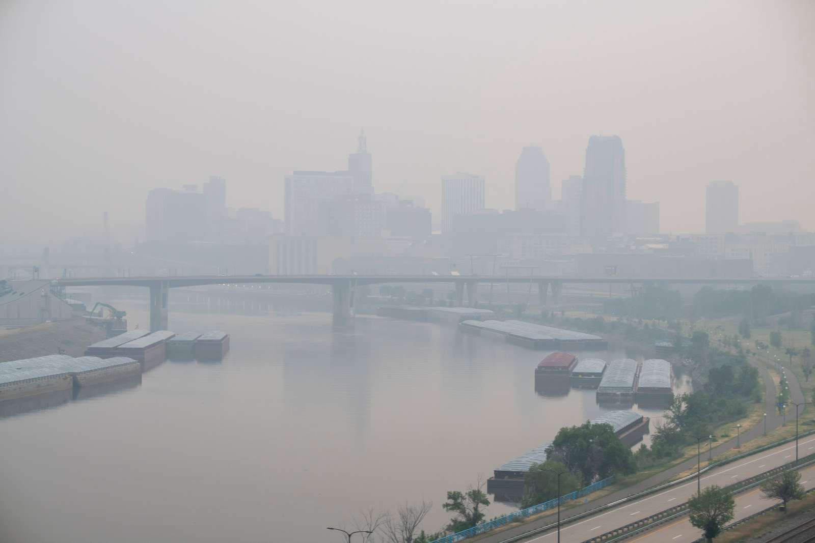
Wildfire smoke from Canada casts a thick haze over St. Paul, Minnesota, June 15, 2023.
Michael Siluk / UCG / Universal Images Group via Getty Images
Tulsa, Oklahoma, was once the country’s most frequently flooded city, according to the assessment. After a disaster in 1984 submerged 7,000 homes and killed 14 people, the city came together to fix the problem with an aggressive flood-control plan. They constructed a network of drainage systems, created green spaces to soak up water, and put strict rules on where new homes could be built. Over the last three decades, Tulsa has also cleared roughly 1,000 buildings out of flood zones through a buyout program. Officials say the effort has saved the city millions of dollars, and the Federal Emergency Management Agency gave Tulsa its top risk-reduction rating last year.
That’s the kind of tough work that lies ahead of any Midwest city aiming to protect its residents. With dam failures and overflows from combined sewer and stormwater systems common, the region is unprepared to handle the volume of water now coursing in. “Just being more sheltered from certain dangers does not make you a haven,” said Julie Arbit, who researches equity and the environment at the University of Michigan. And flooding isn’t the only problem. Purported climate havens like Minneapolis, Duluth, Ann Arbor, and Madison, Wisconsin, will see some of the greatest temperature increases in the country in the coming decades. Residents of Michigan and Wisconsin face some of the longest power outages in the country.
The idea that any city could be a climate haven traces back to Jesse Keenan, a professor of urban planning at Tulane University — though he suspects the phrase itself was invented by journalists. “People often associate me with coining that concept, but I don’t think I’ve ever used that phrase in any of my talks or writing,” Keenan said (though he did come up with “climate-proof Duluth.”) In 2018, the journalist Oliver Milman wrote an article for The Guardian looking at the parts of the U.S. that might be less miserable as the climate changes, calling Duluth and Buffalo “safe havens.” That framing took off the following year, making the headlines in Reuters, Yale Climate Connections, and Bloomberg.
Keenan said he probably wouldn’t have used the phrase “climate havens,” though he does take credit for the proposition behind it. “The general idea is that there are places that people are going to move to, whether we like it or not, whether we plan for it or not,” he said. “We need to help those places and guide those places to prepare.”
The idea of climate havens caught on, in part, because it was a hopeful message for post-industrial cities in the Great Lakes region, raising the prospect of filling vacant homes and revitalizing sluggish economies. Over the last two decades, more than 400,000 people left the Midwest for other regions of the United States. In 2019, Buffalo’s mayor called his city a “climate refuge.” The title is still embraced by some city planners: The 2023 Green Cincinnati Plan names the city a “climate haven.”
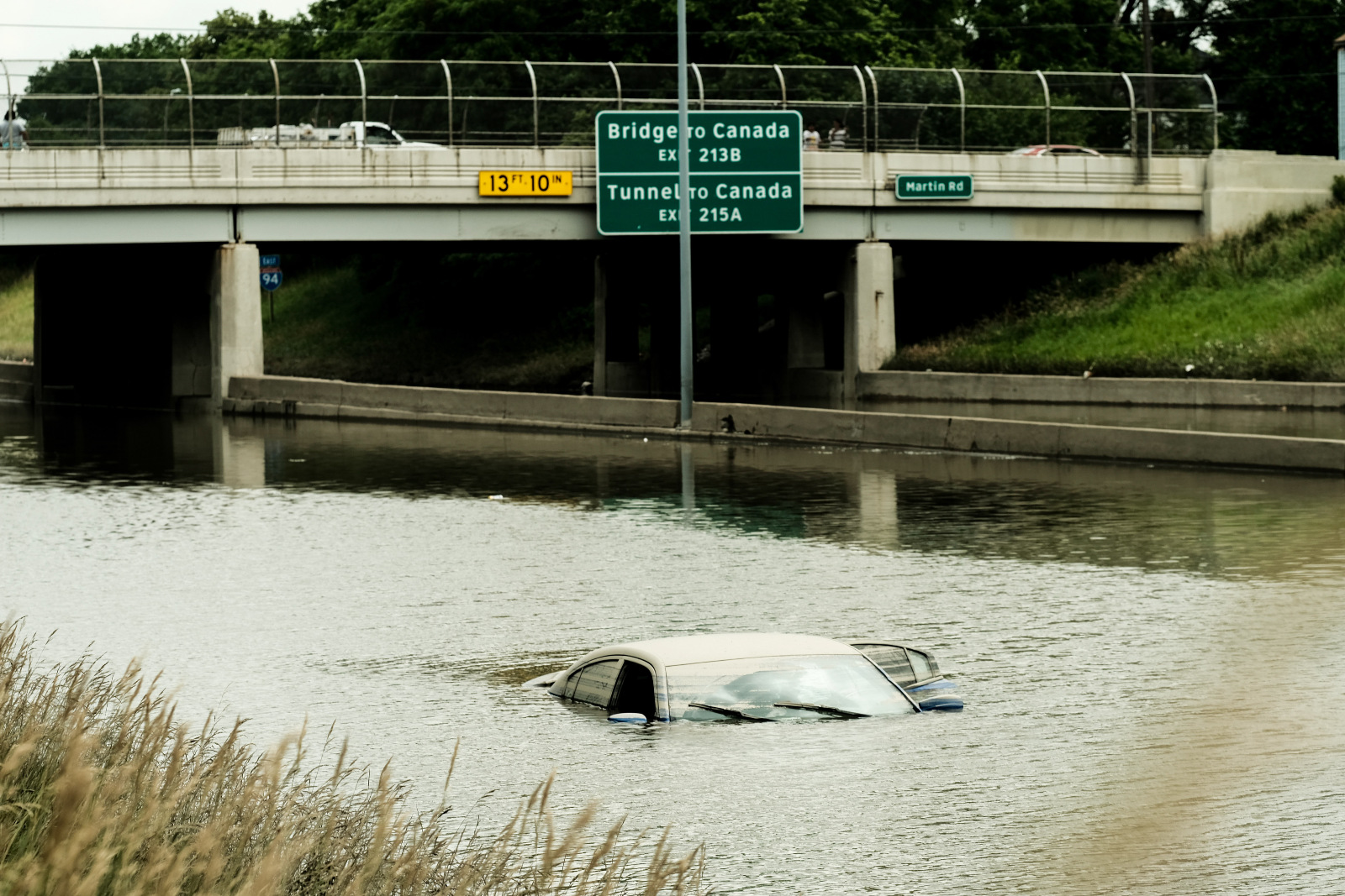
Several days after heavy rains flooded Detroit, Michigan, in June 2021, a car remains inundated on I-94.
Matthew Hatcher / SOPA Images / LightRocket via Getty Images
The reality of climate change has weakened the phrase’s charm. Another factor that could be dampening enthusiasm for havens, according to Shandas, is that researchers aren’t getting much federal funding for their proposals to identify the role climate change plays in propelling migration patterns. The National Climate Assessment, for instance, points out that there’s yet not enough data to “make a strong statement” on how climate change might drive migration to the Midwest.
Beth Gibbons, an author of the Midwest chapter of the report and the national resilience lead with the consulting group Farallon Strategies, says she’s heard many anecdotes of people moving to the Great Lakes in search of a less hostile climate. Most locals, however, don’t share politicians’ enthusiasm for a wave of climate migration to the Midwest. Interviews across Michigan, Wisconsin, Minnesota, and Western New York have found that people are nervous about the prospect, Gibbons said.
“By and large, the sense in communities is that we have a lot of challenges as it is,” Gibbons said, “and they’re not sure that this sounds like something that is really an opportunity, but rather something else that they may have to be dealing with.” Environmental justice advocates also worry that “the idea of being a climate haven is going to become a distraction from caring for people who are already here.”
The “climate havens” conversation has largely revolved around the Midwest, but new research suggests that other parts of the country might be getting overlooked. The Climate Vulnerability Index, released by the Environmental Defense Fund and Texas A&M University last month, maps out risk across the United States on a neighborhood level, measuring environmental dangers alongside factors that make it harder for people to deal with hazards, such as income levels and access to health care. According to data provided to Grist, the least vulnerable counties are mostly rural and scattered across the northern part of the country, from Nantucket County, Massachusetts, to Juneau County, Alaska. The only Midwest spot to make the top 10 was Oneida County in Wisconsin. And the only place with a large population (numbering 600,000 people) on the list was Washington County, Oregon, which includes the east side of Portland.
Portland residents rest in a cooling center on June 27, 2021, during a historic heat wave.
Nathan Howard / Getty Images
Portland has been named as a potential climate haven before, but the idea has recently fallen out of favor after the Pacific Northwest was struck by an off-the-charts heat dome in June 2021. It brought 116-degree temperatures to Portland, melting streetcar power cables and buckling pavement. In a region largely unaccustomed to owning air-conditioning units, roughly 1,000 people died across Oregon, Washington, and British Columbia. “‘Nowhere is safe’: Heat shatters vision of Pacific Northwest as climate refuge,” read a headline in The Guardian at the time.
Two years later, Portland and Seattle are more prepared for heat. “The Northwest went bananas with distributing heat pumps and AC units all over the place,” Shandas said. One bad disaster doesn’t necessarily cross a given place off the “havens” list; people can learn from past events and work to better survive the next disaster.
And the reality is that most people are unlikely to pack up their belongings and move across the country to find refuge. There’s “no doubt that most people will be moving relatively locally,” Keenan said. He says that climate migration, even at a more local level, presents another opportunity to get it right when it comes to urban development. “We can either recreate crap suburban sprawl and high-carbon sprawl, or we can try to do it the right way. But we will branch into new cities in America, and those may be closer to home than we realize.”
“Local refuges” might provide a better framework for discussing how to escape the worst of climate change, Shandas said. He borrowed the concept from the field of ecology, where the Latin “refugia” refers to areas where the climate conditions stay relatively safe over time, despite change happening around them. A local refuge could be a community center with air conditioning during a heat wave. Or it could mean moving out of a wildfire danger zone, or up the hill to escape frequent flooding.
“For me, that’s a wonderful thought,” Shandas said, “because it allows humans to actually not be the victim of, like, ‘Oh my God, no matter where we go, we’re going to be crushed by this climate.’ And it’s like, ‘No, actually, there are things we can do.”
The liquefied natural gas, or LNG, industry has exploded across the U.S. Gulf Coast over the past decade, burying once-remote shorelines under hundreds of acres of concrete and steel, where the fossil fuel is cooled so it can be shipped across the globe. The war in Ukraine has fanned the flames of this buildout, with the federal government urging companies to export the fuel to Europe as it weans itself off Russian gas. While the growth shows no sign of slowing — at least two dozen projects are currently underway — one of the industry’s largest new developments now faces a major hurdle. After years of legal battles, a federal court struck down a key permit for Sempra Energy’s new plant in Port Arthur, Texas, last week, calling the state’s decision to approve it “arbitrary and capricious.”
Sempra’s project, named the Port Arthur LNG Export Terminal, is currently under construction along the Sabine-Neches ship channel, which will give it direct access to the Gulf of Mexico. When operational, it would be capable of producing up to 27 million tons of liquefied natural gas every year, giving it the potential to add more than 7 million tons of greenhouse gases to the atmosphere annually.
The facility, and others like it, also emit chemicals like nitrogen oxide and carbon monoxide, which aggravate the respiratory system. Sempra’s construction site is less than 10 miles from Port Arthur, an industrial city where more than 70 percent of residents are Black or Latino and where a labyrinth of refineries and petrochemical plants release toxic chemicals like benzene into the air day and night.
Local residents and advocates opposed to Sempra’s project argue that it will only worsen public health in an area where asthma and cancer rates already exceed the national average. As a result, many celebrated last week’s decision.
“Every step in this fight, we’ve won by standing up for Port Arthur communities of color to breathe free from toxic pollution,” John Beard, a former refinery worker and one of the region’s most outspoken environmental advocates, said in a press release. “When attacked, we fight back — and win!”
In 2020, the Texas Commission on Environmental Quality, or TCEQ, which regulates pollution for the state, initially approved Sempra’s air permit, which specifies the volume of pollutants the facility is permitted to emit annually. Advocates at the local environmental group Port Arthur Community Action Network immediately requested a hearing to challenge the agency’s decision, arguing that it had applied a substantially less strict standard than those applied to other LNG facilities, particularly the Rio Grande LNG project planned for Brownsville in the southern part of the state. When the latter plant applied for a permit to emit pollution from its refrigeration turbines (the giant engines that cool natural gas down to its liquid state), state officials whittled down the facility’s requested emissions levels by 40 percent, a level that the state said was achievable using emission control technology. But Sempra’s permit, which proposed to use the same kind of turbine, was approved unchanged.
Citing the “arbitrary” nature of these decisions, judges at Texas Office of Administrative Hearings ruled in favor of the community last May, but their ruling was quickly rejected by TCEQ commissioners, who pushed the permit through. The federal Environmental Protection Agency’s regional office in Dallas sent a letter to TCEQ, arguing that officials had failed to state a basis for their decision. Advocates then elevated the case to the federal Court of Appeals for the Fifth Circuit, based in New Orleans, Louisiana, where three judges sided with the community last week, effectively nullifying Sempra’s permit.
“When a Texas state agency departs from its own administrative policy, or applies a policy inconsistently, Texas law requires it to adequately explain its reasons for doing so,” the judges wrote, adding that state environmental officials had failed to do so.
Advocates say that the decision demonstrates TCEQ’s willingness to bend its policies to the whims of fossil fuel companies.
“Our clients wanted to be treated in a consistent manner. They wanted to be protected as well as anyone else out there,” Chase Porter, an attorney at Lone Star Legal Aid who worked on the case, told Grist. “And it was pretty straightforward and clear that TCEQ, for no apparent reason other than that’s what the company proposed, allowed them to have higher emission limits than they’ve allowed elsewhere.”
In a statement last Wednesday, Sempra said that it will “continue to actively evaluate options to mitigate any potential impacts of the decision on project schedule and cost.”
Without its requisite air permit, the company may have to restart the permitting process, correcting the inconsistencies identified by the judges. The company plans for the terminal to be operational by 2027.
This story was originally published by ProPublica, a nonprofit newsroom that investigates abuses of power, and was co-published with The Desert Sun.
Craig Elmore’s family history is the stuff of Westerns. His grandfather, John Elmore, a poor son of a Missouri preacher, arrived in California’s Imperial Valley in 1908 and dug ditches to deliver water to homesteaders.
Thanks to his marriage to a citrus magnate’s daughter, reputed good fortune as a gambler and business acumen, he amassed the Elmore Desert Ranch, part of roughly 12,000 acres that two branches of the family still farm.
All that land in the blazing-hot southeastern corner of California came with a huge bonanza: water from the Colorado River. In 2022, the present-day Elmores consumed an estimated 22.5 billion gallons, according to a Desert Sun and ProPublica analysis of satellite data combined with business and agricultural records. That’s almost as much as the entire city of Scottsdale, Arizona, is allotted.
That puts the Elmores in exclusive company. They are one of 20 extended families who receive fully one-seventh of the river’s flow through its lower half — a whopping 1,186,200 acre-feet, or about 386.5 billion gallons, the analysis showed.
The Colorado River system, which supplies 35 million people in seven U.S. states and Mexico, nearly collapsed last year. Even after a wet winter, it is dwindling due to overuse and climate change. But no matter how low its reservoirs sink, the historic claims of these families and all of Imperial County place them first in line — ahead of every state and major city — for whatever water remains.
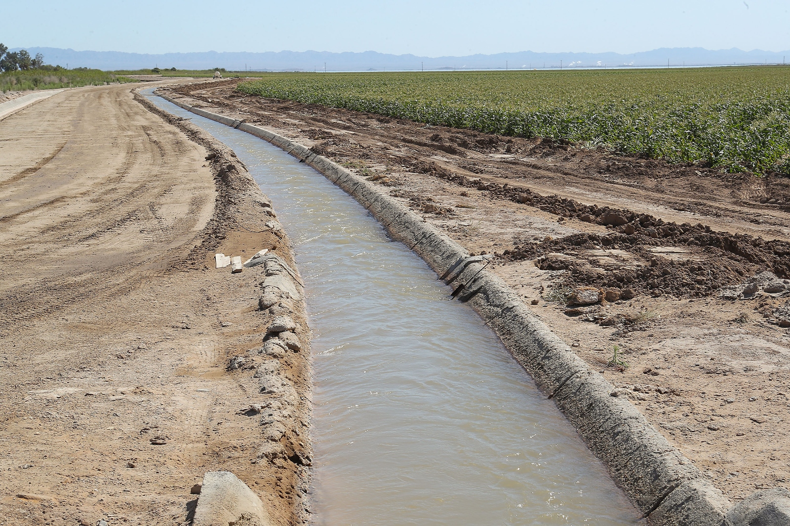
A canal carries water through Elmore Desert Ranch.
Jay Calderon/The Desert Sun
How a handful of families and a rural irrigation district came to control so much of the West’s most valuable river is a story of geography and good timing, intermarrying and shrewd strategy, and a rich but sometimes ugly past when racist laws and wartime policies excluded farmers of color. Together, they winnowed the greatest access to these 20 clans, who today use more of the river than all of Wyoming, New Mexico, or Nevada. A vast, laser-leveled green quilt of crops covers this naturally bone-dry valley, all of it grown with Colorado River water.
The water is held “in trust” by the Imperial Irrigation District and two smaller agencies, meaning they are legally required to deliver the water to any county landowner for use on their property.
But many farmers here see the river water as virtually their private property, though nearly all acknowledge it can’t be sold apart from their land.
“It’s not a public resource,” says Rachel Magos, executive director of the Imperial County Farm Bureau. “It’s called prior perfected rights.”
That phrase “prior perfected rights” is shorthand for legal decisions spanning 100 years, including three by the U.S. Supreme Court, that have perpetuated those rights since early would-be developers staked claims for the Imperial Valley that amounted to the river’s entire flow.
Blood ties, and the ceaseless buying of lands from less successful farmers or descendants who want a “windfall,” have concentrated thousands of farm fields and the water that comes with them into an ever-smaller number of hands, says county tax assessor Robert Menvielle.
Menvielle, a third-generation resident, and his extended family own about 1,700 acres that they largely lease to farmers, some of whom he’s known his entire life. “You’ve got this small group of families, and … they’ve all intermarried, and it’s almost like a feudal-type system, where we’re combining our little kingdoms,” he says.
Those fiefdoms exclude most of Imperial’s 180,000 residents. Agricultural operations — which in addition to historic farming families include universities, the Mormon Church, outside speculators, and a Middle Eastern hay company — get 97 percent of the irrigation district’s river water, while every town, strip mall, and other business combined get 3 percent. And the county ranks among the poorest in California, with a 2021 per capita income of $19,005. The U.S. per capita income that year was $70,480.
Irrigation district spokesperson Robert Schettler didn’t dispute the Desert Sun and ProPublica analysis showing who uses the valley’s water and what they do with it. But he said in a statement that despite distributing half of its water to 20 extended families, the district “provides equitable water delivery service to all,” including small landowners, towns, and businesses.
The disparities in wealth and water disturbed Benny Andrés Jr. when he was growing up in Imperial County, and he became a historian partly to study their origins.
“How is it that a region conducive to year-round farming, with half a million acres of rich soil, plentiful and subsidized water … has bred widespread poverty and unhealthiness?” Andrés, now an associate professor at the University of North Carolina at Charlotte, asks in his book, Power and Control in the Imperial Valley. His research shows that outside speculators and absentee landlords also amassed huge amounts of land and water while people of color were systematically excluded, condemning most to eventual poverty.
Growers say that without agriculture, unemployment and poverty here would be even worse.
Meanwhile, outside threats to the area’s outsize water supply are looming. As federal officials force hard choices to keep the river afloat, states and cities facing water cuts are eyeing the Imperial Valley. The big farmers and their irrigation district say they know they’ve got a target on their backs.
Jay Famiglietti, a University of Arizona hydrologist who studies global water supplies, says large-scale farming in southwestern deserts like the Imperial Valley is “not sustainable, it just can’t go on.” Ultimately, production may need to shift to wetter regions.
Elmore and other farmers say that could devastate year-round food supplies in the U.S. — you can’t grow leafy greens and alfalfa in the Midwest in February. But they are striving to use far less water and to devise new ways to profit from an ancient flow.
Just add water
Elmore’s grandfather arrived a year after the Southern Pacific Railroad forced the then-raging Colorado River to resume its normal course to Mexico, ending two years of flooding in the valley. For eons, the river was a wild, unpredictable force that shaped this landscape. At times, it flowed west and north into a huge trough between emerging mountain ranges. Here, the ancient river deposited millions of tons of mineral-rich soil.
In the mid-1800s, physician O.M. Wozencraft, a would-be land developer, realized that if the river could be diverted into its ancient path, the silty top coat of what was then known as “the Valley of Death” could be farmed. He persuaded California to deed him most of present-day Imperial County, but he couldn’t convince Congress to pay for a canal to carry river water to his land. A member of Congress called the scheme a “fantastic folly of an old man.”
But the lure of that water was irresistible. From 1895 through 1899, according to M.J. Dowd’s book, “The First 40 Years,” dreamers, schemers, and agents for land barons posted notices on the river’s western bank, invoking California law protecting downstream mining claims, and filed them with the county recorder. “Each of these appropriations was for a flow of 10,000 cubic feet per second of the water of the Colorado River,” writes Dowd.
Collectively, they claimed the river’s entire flow and then some, Andres says. “They wanted it all, they didn’t want Arizona or anybody else to get a drop.”
But he and other experts note such claims had to be actively worked on, by seeking investors, building infrastructure, and eventually providing water for “beneficial uses.”
By 1901, the California Development Co. had acquired rights to as much water as it could use. That year, Colorado River water was diverted via the first canal to what had been grandly christened the Imperial Valley, and by 1910, thousands of small farmers had arrived. The following year, the Imperial Irrigation District was formed, and a few years later, it bought out the private company and its rights.
Restless young men from India, Japan, Europe and the eastern U.S. arrived in the next 30 years. Many quickly went belly up and sold to more successful neighbors, like ancestors of the Elmores, Abattis, Strahms, Saikhons, Taylors, Morgans, Schaffners, Grizzles, Brandts, LaBrucheries, Rueggers, and Osterkamps, all among the top 20 families using Imperial water today.
No limits
The rose-colored vision of hardy pioneers “settling” the “virgin West” — after driving Native Americans from their ancestral lands — was enshrined in the federal Homestead Act of 1862 and Reclamation Act of 1902. Farmers were permitted to occupy and irrigate a maximum of 160 acres of free land and make it their own.
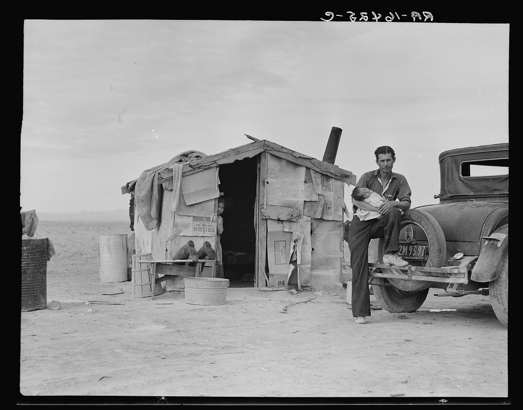
A migrant farm worker from Mexico outside his home on the edge of a pea field in the Imperial Valley in 1937.
Dorothea Lange, Library of Congress
However, Imperial County landowners and complaisant U.S. Bureau of Reclamation officials ignored that limit, allowing rapid consolidation of land, says Andrés, who wrote his doctoral dissertation on the county’s early years. Thousands of formerly small holdings were now “farm units” absorbed by growing spreads like the Elmores’, a cotton syndicate, and hundreds of absentee landlords, he found. A 1924 report estimated 85 percent of Imperial landlords lived on the California coast or out of state.
Many farmers in the county were not white: By 1922, there were 2,200 Japanese immigrants farming 28,000 acres, and 495 people from India farmed 36,000 acres. Japanese growers, some of whom had worked on Hawaiian pineapple plantations, were often highly skilled and successful across California. Similarly, immigrants from the Punjab region of India knew how to coax vegetables from the valley’s often claylike soil in triple-digit heat. Some owned land; others farmed absentee owners’ holdings.
These migrants regularly endured racism. Landowners, county officials, and even farmers of differing nationalities ranked migrants — Japanese, Indians, Filipinos, Mexicans, and eventually Black southerners — in terms that would be familiar to white eugenicists. They classified them by their farming knowledge, ability to do backbreaking labor in searing heat and “reliability,” which meant they were unlikely to walk off the job or to demand higher wages or better living conditions.
“Like immigrants always, these groups were more desperate to succeed, so they were willing to work harder,” Andrés says.
White groups statewide decried the success of people of color. State Alien Land Laws banned Asians from owning land or leasing it long term. The U.S. Supreme Court upheld the second ban, but it was rarely prosecuted in Imperial. Still, it was not easy. Japanese families built wooden “mobile” shacks that they could carry from one set of fields to another after leases ended or if they were forcibly evacuated.
The exclusionary law drove out people of color who worked as merchants, too, and “began to depopulate the countryside,” said Andrés. Many large landowners also ceased using full-time workers who lived nearby and hired contractors to bring in cheap, temporary labor from across the border.
Elmore says his grandfather operated differently than many during that era, building a school that all children from the surrounding remote area could attend. Elmore still lives in Imperial County, has about 50 full-time employees, and pays their health and life insurance benefits.
Today, instead of a vibrant local workforce, thousands of day laborers line up as early as 1 a.m. at the Mexicali-Calexico border, waiting for hours to be bused to fields, then back again. Meanwhile, Imperial had the highest unemployment rate in California in September, 19.7 percent, compared with 4.4 percent statewide.
Imperial Valley United
When the Great Depression hit, a flood of Dust Bowl “Okies” and other poor white and southern Black migrants arrived, upending the “whites first” racial caste system.
A Dust Bowl refugee living in temporary housing in Imperial County in 1937.
Dorothea Lange, Library of Congress
A few years later, during World War II, anti-Asian sentiment reached a fever pitch. FBI agents forced more than 100 Japanese community leaders from their homes in February 1942, including a Buddhist priest and a Christian minister. Then on two nights in May of that year, the entire Japanese population of Imperial County — hundreds of successful farmers, merchants, religious leaders, and their families — was removed from their homes to be forcibly relocated to the Poston incarceration camp in Arizona. Some of the valley’s first farmers were among those imprisoned.
Their parcels, like land owned by detained Japanese farmers across the state, were likely acquired by neighbors and investors at foreclosure sales. Elmore says his grandfather and father had Japanese farmer friends who were forcibly removed. “That shouldn’t have happened,” he says. He’s not sure who acquired the local Japanese families’ land. “I know we didn’t.”
Near the end of the war, a huge anti-Japanese rally was held on the Brawley high school football field. A resolution was adopted petitioning the president, Congress, and governor of California and protesting the return of any Japanese people to the Imperial Valley. Speakers at the rally condemned local churches for trying to aid their former neighbors.
There were financial motives behind the xenophobia. Powerful white shippers and growers organized the event, telling the local chamber of commerce that two people from the Poston camp “had appeared in town, announcing their intention to return to Brawley.” About 2,500 more former Imperial Valley residents of Japanese ancestry were due to be released.
A broad coalition of community groups dubbed “Imperial Valley United” vowed to permanently exclude Japanese people from the valley. Today, one Japanese-American farmer is listed on the Imperial Valley Vegetable Growers Association roster, and it’s not clear if he used any water last year.
“Prior perfected”
Imperial officials lobbied for years for massive federal infrastructure to “tame” the Colorado and diminish the impact of drought and flooding. Growing southwestern cities wanted a steady water and power supply, too. It took until 1935 to complete what was then the world’s largest dam, in Boulder Canyon, Arizona.
In exchange for Hoover Dam, California and six other states signed a “Law of the River” compact. It divided the Colorado into upper and lower basins and set maximum amounts that each could take annually.
The Imperial Irrigation District had to agree for the first time to cap its river allocation. On paper, the era of no limits was over. But in practice, the agency would for decades order as much free river water as its farmers wanted.
There were challenges to their dominance.
As Phoenix and other cities in the Southwest grew exponentially, Arizona challenged California’s historic claim to the Colorado River. Arizona lost, but in 1960, the U.S. Supreme Court decided that California would keep 4.4 million acre-feet, Arizona would be entitled to 2.8 million acre-feet and Nevada would get 300,000 acre-feet. Imperial County came out on top, with a legal claim to three-quarters of California’s share.
An idealistic New York doctor named Ben Yellen, who had built a practice in Brawley caring for low-income residents and farmworkers, also wrote “yellow sheets,” denouncing Imperial landowners’ long-standing violation of the 160-acre homesteading limit and the irrigation district’s delivery of massive amounts of river water to them in violation of the 1902 Reclamation Act. He successfully intervened in a case challenging the water district, and California’s highest court eventually ruled the 160-acre irrigation limit had been illegally ignored.
But Elmore’s father and other major farmers fought back. In 1980, the Supreme Court ruled that the farmers could keep their large tracts and all the river water being delivered to them. The court ruled that the Imperial Irrigation District held “prior perfected” rights acquired from private irrigation companies under state law, neither of which had imposed limits on how much acreage could be irrigated. A framed copy of the decision hangs on Elmore’s ranch office wall.
U.S. Senator Alan Cranston that year slipped language into a bill supposedly designed to reform the Bureau of Reclamation that permanently exempted Imperial County farmers from the 160-acre limit.
The number of farmers continued to shrink. From the 1960s to the 1990s, hundreds of smaller Imperial County farmers — largely descendants of Filipino migrants and other people of color — were decimated. U.S. Department of Agriculture research led to sturdier tomatoes that could be transported long distances, including from Mexico, which slashed demand for tastier but more perishable tomatoes grown by more than 500 Filipino farmers in and around Niland, in the valley. The North American Free Trade Agreement sent even more farming across the border, wiping out more small Imperial operations.
Sending water to cities
It was the Elmores who first cost their fellow growers some water. In 1982, Craig Elmore’s dad sued neighboring farmers and the irrigation district. The Elmores’ land sat at a lower elevation than nearly every other farmer’s fields, and they alleged that aging canals and overwatering by some had caused costly flooding on their fields.
The courts found that the irrigation district and its farmers were wasting water. The settlement agreement forced the district to partner with the urban Metropolitan Water District of Southern California, which supplies 19 million residents in coastal counties. In exchange for a cut of Imperial’s water, Metropolitan Water District funded the lining of the earthen All-American Canal and miles of side ditches.
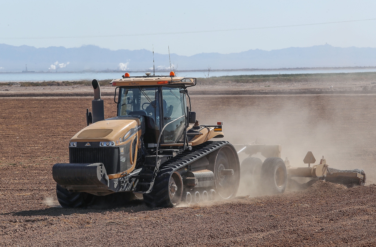
A tractor works a field at the Elmore Desert Ranch in 2019.
Credit:Jay Calderon/The Desert Sun
As cities and suburbs drew millions more residents, Imperial’s power continued to erode. In 2002, President George W. Bush’s Interior secretary, Gale Norton, threatened to take some of Imperial’s water for cities; a year later, U.S. Senator Dianne Feinstein bluntly warned Imperial Irrigation District officials that if they didn’t agree to transfer 300,000 acre-feet per year to suburban San Diego and the Coachella Valley, the U.S. Interior secretary might strip away their “senior” water rights. It would be the largest transfer of agricultural water to an urban area in the nation’s history, and the irrigation district would be paid handsomely by urban customers.
A thin majority of the district’s board approved the deal. Most farmers have now accepted that they, like everyone else, have a limit on how much water they can use. But with urban areas wielding far more political power, some are not sure there will be farming here in another century.
“We adapt”
Ralph Strahm, who with his brother and nephews used an estimated 81,000 acre-feet of water last year, the second-highest amount in the district, thinks people’s need for drinking water may win out over the need for food in most politicians’ minds.
He and other prominent growers are willing to seasonally fallow some fields for two months during the summer, if they’re paid to do so and keep their “senior” river rights. The federal government is weighing whether to award Imperial Irrigation District and local growers more than $600 million not to farm certain fields.
Andrés, the historian, says that approach is what led to most of the county’s impoverishment. He has his own vision for the valley’s future: The irrigation district and farmers should sell less-productive or unused land and pay out of their own pockets to ensure they use water efficiently. Public funds and training should instead support the diverse group of small farmers, he says.
But Elmore says hefty public subsidies and possible private investments are needed for farmers to grow crops more efficiently, then be paid to possibly transfer the conserved water elsewhere or leave it in the river’s massive reservoirs.
Elmore’s son is the southwest region farm manager for Water Asset Management, a Wall Street investment firm whose mission is to tap into a potential trillion-dollar water transfer market. Elmore has spoken at WAM’s annual meetings, and like another top vegetable farmer, Jack Vessey, now leases and farms acreage that WAM has bought in the valley.
Elmore is building support in the irrigation-district for funding a $4.4 million pilot reservoir on his land, which could ultimately hold water for farming or for sale. The private sale of water outside the valley is currently prohibited, but that could change if public funding for conservation dries up.
However it shakes out, the Elmores and Imperial’s other dynasties will likely continue profiting from the Colorado River.
“I’m optimistic,” Elmore says in a throaty rumble. “Every time there’s a change, we adapt. If there’s one thing the Imperial farmer has learned how to do in these harsh conditions, it’s to adapt.”
Elmore, 66, says he’s thinking about who will benefit long term: “My grandson is 6 years old. I’d like to see him go into farming.”
This story was originally published by the Arizona Mirror.
In an effort to address the ongoing drought affecting the Southwest, the Gila River Indian Community is taking an innovative step forward by launching its Solar Canal Project to construct the country’s first solar-over-canal project.
“A tribe is leading the way,” Gila River Indian Community Governor Stephen Roe Lewis said, adding that the shovel-ready project will immediately address water conservation.
The Gila River Indian Community and the U.S. Army Corps of Engineers signed an agreement on Thursday in Sacaton, Arizona, kicking off construction on the first phase of the Pima-Maricopa Irrigation Project Renewal Energy Pilot Project, which is expected to be completed in 2025.
“This new technology fits and supports our culture and tradition as we look forward to being sustainable in the future in a very real way,” Lewis said. The project may break new ground for the tribe, but he said it furthers their role as stewards of their water.
Lewis said they’re looking at this in terms of a Blue-Green Tribal Agricultural Economy, in which blue represents conserving water and green symbolizes renewable energy.
The GRIC has over 150 miles of canal that could ultimately be covered with solar panels, and this project could be a game-changer for creating energy.
The first phase of the project involves the construction of solar panels over a portion of the GRIC’s Interstate 10 Level Top canal, according to the tribe, and the project works to conserve water and generate renewable energy for tribal irrigation facilities.
David Deyoung, the director of the Pima-Maricopa Irrigation Project, said there are two ways this project can conserve water: reducing the evaporative water losses and minimizing water use for power generation. The combination, he said, will save about 200 acre-feet a year.
The project is expected to produce approximately 1 megawatt of renewable energy to offset energy needs and costs for tribal farmers, according to the GRIC.
The solar panels are expected to cover more than 1,000 feet of the canal as part of phase one of the project. Lewis said he hopes to launch phase two in December, which involves installing solar panels on top of more canals near Casa Blanca.
Lewis said it’s great to see all the plans come to fruition, and he believes that the Gila River Indian Community is setting new ground for other tribes to follow.
Earlier this week, the U.S. Global Change Research Program released the United States’ Fifth National Climate Assessment, an overview of the effects climate change is having on the country.
The main message of the assessment is clear: Every part of the country will experience weather extremes due to climate change.
“There is not a part of the U.S. that gets a pass on climate impacts,” a Biden administration official said, as Inside Climate News reported.
The assessment is a federal report mandated by Congress that provides a comprehensive overview of climate change effects across the U.S.
All over the country, changes in climate are causing more intense drought, heat waves, wildfires, floods and hurricanes, which are taking an increasing toll on people’s mental health.
Each region of the country will experience its own climate-related disasters. For example, the Northeast has some of the most extreme rainfall and flooding, the Biden administration official said.
“In the Northeast, we have some of the oldest infrastructure in the country and a lot of it obviously faces pretty extreme conditions given the kind of strong seasonality we experience here,” said Dave Reidmiller, co-author of the Northeast chapter of the assessment and director of the Gulf of Maine Research Institute’s Climate Center, as reported by Inside Climate News. “So whether that is dams or our electrical grid, or roadways, culverts, wastewater treatment plants, you name it, they all face risks from climate change and the fact that they are aging means that there’s likely to be increased risk to them.”
Residents in the Southeast suffer from stifling heat and humidity. While in the West, drought and wildfires affect air quality and put stress on water supplies and agriculture.
Coastal areas are experiencing flooding with high tide that is getting worse as sea-level rise washes through neighborhoods. Midwestern states are grappling with a combination of extreme heat, drought and flooding, which are all affecting agriculture.
The assessment found that nationwide climate impacts are disproportionately affecting those who are less wealthy, as well as Black and Indigenous communities and people of color.
“The institutions of slavery and intergenerational ownership of individuals as property, Jim Crow segregation, and housing discrimination have resulted in many BIPOC (Black, Indigenous, and People of Color) communities living in neighborhoods that are disproportionately exposed to environmental risks and with fewer resources to address them when compared to majority White communities,” the report said.
Other regions of the country have inequities as well, according to the assessment.
“Underserved and overburdened communities face disproportionate risks and impacts from climate change, which exacerbates existing social and economic inequities. Some overburdened communities are at higher risk of climate impacts due to ongoing systemic discrimination, exclusion, and under- or disinvestment. These social inequities contribute to persistent disparities in the availability of resources needed to prepare for, respond to, and recover from climate impacts,” a press release from the White House said.
Along with the report, the White House announced $6 billion in investments toward climate resilience efforts, including bolstering the aging infrastructure of the electric grid, supporting conservation efforts, reducing flood risks and advancing environmental justice.
All regions of the U.S. have started making efforts to adapt to climate change and curb their contributions to the climate crisis. The most action has come from the Northeast and Southwest, including California, Inside Climate News reported.
Most regions of the country are experiencing a billion-dollar disaster an average of every three weeks, especially in the Midwest and along the coasts.
In the Southeast, population growth is causing more people to be exposed to climate impacts like hurricanes, rising sea levels and extreme heat. At the same time, adaptation plans have frequently been based on information that is limited or outdated and does not account for future risks.
”We’re moving more people into harm’s way, and we’re not doing it in a very coordinated way,” said Kathie Dello, a North Carolina state climatologist who is one of the co-authors of the study and director of the North Carolina State Climate Office, as reported by Inside Climate News. “Our cities just aren’t moving fast enough to keep up with climate change.”
Sea-level rise is a consistent threat to coastal communities, with the Southeast particularly at risk. Sea levels have risen by six inches relative to land elevations from 1970 to 2020. Future projections are for an additional 16 to 23 inches by mid-century and two to seven feet by the end of the century. Saltwater has already inundated coastal estuaries and forests, reducing their ability to sequester carbon.
“Climate change is here,” says Arati Prabhakar, President Joe Biden’s chief science adviser, as Nature reported. Prabhakar added that the country is making significant new investments in climate measures.
The government’s $2 billion in funding for community-based environmental justice grants and $3.9 billion for modernizing the electric grid, as well as several hundred million aimed at helping secure reliable community water supplies and flood resilience, offer some hope.
“This is not about curling up in a corner in despair,” said Rachel Cleetus, lead economist and policy director for the Climate and Energy Program at the Union of Concerned Scientists, as reported by Nature. “There are very concrete steps we can take to cut our emissions and to promote climate resilience.”
The U.S. Department of Agriculture has updated its Plant Hardiness Zone map, a map of the U.S. that helps gardeners decide what plants will grow best in their local areas, based on average annual extreme minimum winter temperature. The updates show an average of 2.5°F warmer across the contiguous U.S. compared to the previous map, which was published in 2012.
Experts used used a 30-year period of data, from 1991 to 2020, to develop the latest edition. They also pulled data from 13,412 weather stations, an increase from 2012, when experts used data from 7,983 weather stations. This increase in stations, combined with more advanced technology, has led to the most comprehensive and accurate Plant Hardiness Zone map to date.
The USDA noted that changes in climate are typically based on trends from 50 to 100 years’ worth of data, not 30 years, so the USDA doesn’t consider zone changes in the map to be evidence of climate change. Further, the variables that were used to develop the map can change significantly.
“Changes to plant hardiness zones are not necessarily reflective of global climate change because of the highly variable nature of the extreme minimum temperature of the year,” a USDA spokesperson told NPR.
But the map did have a shift of about one quarter-zone warmer throughout the country compared to the 2012 map. As Axios reported, parts of the Midwest and Great Plains had some of the greatest shifts into warmer zones.
“Overall, the 2023 map is about 2.5 degrees warmer than the 2012 map across the conterminous United States,” Christopher Daly, director of the PRISM Climate Group at Oregon State University and lead author of the map, said in a press release. “This translated into about half of the country shifting to a warmer 5-degree half zone, and half remaining in the same half zone. The central plains and Midwest generally warmed the most, with the southwestern U.S. warming very little.”
The shifts mean that many people around the U.S., especially where there were significant zone shifts, can more successfully grow plants that may be new to them. Although many gardeners are interested in the possibility of growing different types of fruits, veggies and other plants, there are also concerns about long-term warming.
“We’re excited, but in the back of our minds, we’re also a little wary,” said Megan London, a gardening consultant based in Hot Springs, Arkansas, as reported by NPR. “In the back of our mind, we’re like, ah, that means things are warming up. So what does this mean in the long run?”
Although the specific map changes haven’t been attributed to climate change, Daly and other experts said that the zones could gradually shift north in the long-run because of global warming.
Microplastics — tiny fragments of plastic products and industrial waste — are now so pervasive in Earth’s environment that they are found everywhere from the highest mountain peaks to the deepest parts of the ocean.
According to a new report, all aquatic species in the mouths of rivers that flow into the Atlantic Ocean and the Mediterranean Sea are contaminated with microplastics; mollusks are the most affected because they are capable of filtering large volumes of water.
Rivers are a main source of microplastics and nanoplastics pollution in the world’s oceans, according to the Universitat Autònoma de Barcelona (UAB). Microplastics are plastic pieces that range from 0.0001 to 5 millimeters, while nanoplastics are those smaller than 0.0001 millimeters.
Microplastics are prevalent in the waters and sediments of estuaries, where a freshwater stream or river meets the ocean. Chemicals can be retained by these tiny plastic particles and threaten aquatic ecosystems when animals ingest them.
“Pollution is ubiquitous in estuaries and their adjacent coasts, in the Mediterranean, and in tropical and temperate zones,” said Patrizia Ziveri, oceanographer at Institute of Environmental Science and Technology of the Universitat Autònoma de Barcelona (ICTA-UAB) and coordinator of the international project “i-plastic,” which analyzed the presence of these plastics in estuaries and adjacent coastlines, reported UAB. Ziveri pointed out that the number of sedimentary particles has increased in recent times, alongside global plastics production. In fact, since 2000, the amount of particles deposited on the ocean floor has tripled.
The findings of the i-plastic project were that 53 percent of oysters and 85 percent of mussels had ingested microplastics. Of marine fishes dependent on estuaries, such as white mullet, Brazilian mojarra and silver mojarra, 75 percent had ingested the plastic particles. In regions along the coast that were influenced by estuarine outflow, 85 percent of Norwegian lobster and 86 percent of European hake were found to have synthetic microfibers or microplastics in their stomachs.
According to scientists, nanoplastic pollution may be an even more serious concern than microplastics and pose a greater threat to aquatic organisms, as nanoplastics are able to penetrate the cellular membrane and cause more harm to species in marine and estuarine environments, as was seen with mussels.
Microplastics and nanoplastics pollution poses a worldwide threat to all coral reef systems, as they cause a reduction in the growth of coral reefs.
Microplastics pollution is especially high near outflows from wastewater treatment plants and urban centers, from which microfibers, which are the most common kind of microlitter, are discharged into estuaries.
“Microplastics and nanoplastics are mostly formed by the fragmentation of larger plastic items. Polyethylene, one of the most common plastic polymers produced, is more susceptible to surface oxidation, the first step in the fragmentation process. Investigating these processes under different environmental conditions is of paramount importance because they can suggest the types of synthetic polymers that are less prone to fragment into microplastics,” the report said.
Once they are trapped in the seabed, these plastic particles do not degrade from exposure to oxygen, erosion or light.
“Plastics from the 1960s still remain on the seabed, leaving the signature of human pollution,” said project coordinator Michael Grelaud, who is also an ICTA-UAB oceanographer.
Particles that do not settle on the seafloor could be transported by ocean tides and currents many miles in only a few months.
“A microplastic from the Ebro estuary in the Northwestern Mediterranean Sea can reach Sicily, in Italy, in six months,” Ziveri said.
Filter-feeders of various species were able to remove nearly 90 percent of microplastics found in surrounding waters, according to lab experiments. The researchers emphasized that using living organisms to remove pollutants from the water, known as “bioremediation,” is one of the only viable options for reducing microplastic pollution found in coastal marine environments.
If you’re looking to get away from the rushed routine of modern life, these four car-free towns, each with its own languid pace, might be just for you.
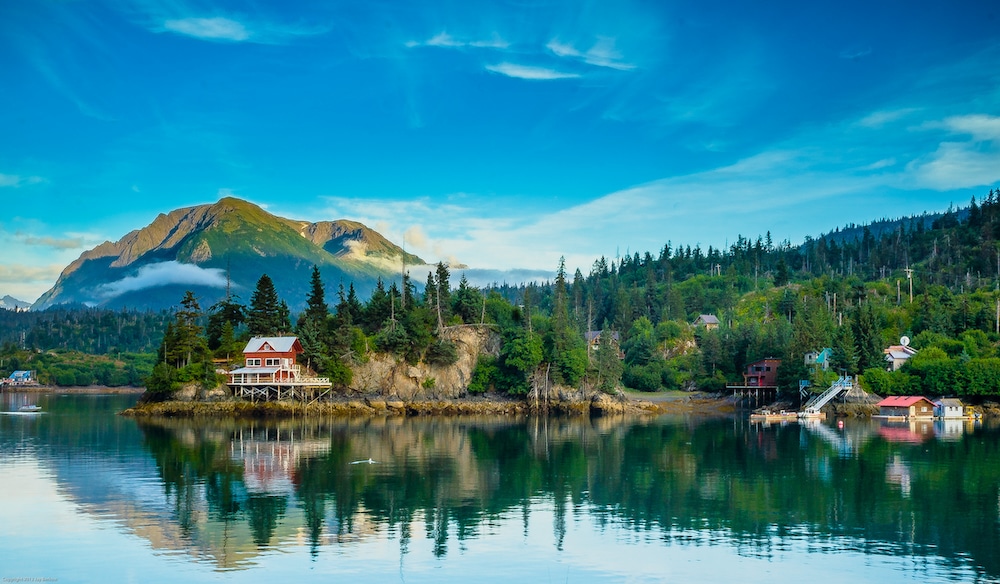
Halibut Cove, Alaska
Halibut Cove is a boat ride across Kachemak Bay from Homer, Alaska. Jay Berkow Photography / Moment / Getty Images
Alaska is a land of unspoiled wilderness and abundant wildlife. If there is going to be a human community there, it makes sense for it to be car-free.
The 400,000-acre state park features mountains, glaciers, coastline, ocean and forests. Stunning views of the Kenai Mountain Range with its spectacular Harding Icefield give this little sanctuary a presence like no other.
For thousands of years, Alaska Native Peoples occupied the area around what is now Halibut Cove. The town itself was founded around 1911 by Scandinavian settlers.
To get to Halibut Cove, you can catch a water taxi in Homer, Alaska, and getting around the 8.12-mile island is done on foot, boat or all-terrain vehicle.
Activities in this tucked away village include hiking, kayaking, strolling along the bay or visiting local art galleries. There are a number of trails, and if you’re up for a long hike, the 6.5-mile Grewingk Glacier Trail will lead you through unspoiled forest of cottonwoods and spruce to shimmering Grewingk Glacier.
There are a variety of lodges and other accommodations in Halibut Cove, as well as a coffee shop and restaurant. Besides being free of cars, another unique feature of the town is that it is home to one of the only floating post offices in the United States.
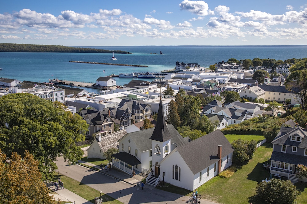
Mackinac Island, Michigan
A view of the town in Mackinac Island, Michigan. Wiltser / E+ / Getty Images
Famously the setting for the Christopher Reeve-Jane Seymour film Somewhere in Time, Michigan’s Mackinac Island feels similarly timeless. Known for its sunrises, quaint boutiques and local fudge, this motorized vehicle-free town has nature trails instead of roads. More than 80 percent of the 3.8-square-mile island is part of Mackinac Island State Park, the first state park in both the state and the country.
“As soon as I board the ferry for the short trip to Mackinac Island, I immediately feel more relaxed. The pace of transportation on the island is slower than on the mainland and, without a car, I interact more with my surroundings. Whether traveling by foot, in a carriage, or on a bicycle, I’m more connected to the sights, sounds, and even the other people there,” Michigan novelist Cynthia Birk told EcoWatch.
The island is located between the upper and lower peninsulas of Michigan on Lake Huron and has plenty of 19th century architecture and comfortable inns, but no chain hotels. The entire island and its natural harbor, Haldimand Bay, located at the south end, are a National Historic Landmark.
“I love being on the island in the early morning or in the evening. It’s so quiet compared to the busy energy of midday. If I’m near an open window or sitting on a beautiful porch and hear the clip-clop rhythm of a horse-drawn carriage going by, it’s like a little moment of time travel. I feel more connected to the history of the area. It’s a wonderful experience!” Birk added.
Supai, Arizona
Camping and swimming are permitted at Havasu Falls. skiserge1 / iStock / Getty Images Plus
If you’re looking to not only get away from cars and roads, but civilization together, you can take an eight-mile hike to Supai, the most remote town in the continental U.S. Not only are there no roads in Supai, there are no roads to Supai.
Members of what is now the Havasupai Tribe — Havasupai means “people of the blue-green waters” — have lived in this village on the edge of the Grand Canyon for 1,000 years. The Havasupai Indian Reservation was established in 1880, but substantially expanded in 1975. It consists of 188,077 acres of land on the South Rim of the Grand Canyon.
To get to the closest point to the Village of Havasupai by car, follow historic U.S. Route 66 to Highway 18, then drive 63 miles to Hualapai Hilltop. This is the point from which you will hike down into the village. All supplies in the village, located in Havasu Canyon, must be brought in by mule or on foot. Even the mail is delivered by mule. Once in the village there is a lodge and a store with a café.
The blue-green waters of Havasu Creek feed into Havasu Falls. Camping and swimming are permitted at the falls and in the creek, which maintains a temperature of about 67 degrees Fahrenheit year-round, a little chilly, but good for a refreshing swim after a long hike. The creek is a tributary of the Colorado River, the architect of the Grand Canyon.
Due to the lack of cars, city lights and noise pollution, camping in Supai to the sound of rushing water under a blanket of stars is a true escape from modern civilization.
Monhegan Island, Maine
Houses overlooking the ocean on Monhegan Island, Maine. Philip Gould / Getty Images
Monhegan Island was first settled by Native Americans who fished its plentiful waters. Meaning “out-to-sea island” from the Algonquin word “Monchiggon,” there are no bridges or roads connecting this one-of-a-kind getaway to the mainland. Scheduled boat service, which does not allow cars or bicycles, is available from Boothbay Harbor, New Harbor and Port Clyde.
The only way to explore Monhegan Island is on foot over 17 miles of hiking trails and dirt paths that wind along the island’s one square mile of rocky terrain.
“I’m on the island, looking across at Manana Island, all bare but for a few crouching spruce trees, two thatched cottages, and, other than that, just grass, sheep, goats. It looks like the Arans out there,” writer and teacher Shaina Kapeluck shared with EcoWatch from writings on Monhegan Island. “[G]aily-colored Adirondack chairs, fierce ochre lichen on the chimney stones. Gnarled wind-riven spruces full of mourning doves, berms of unripe currants, more rugosa roses, the brightest I’ve ever seen. A [m]inke whale surfaced when our ferry approached the island. Willow, buttercups, cattails and fern, bluebells, plants I’ve never seen. Cormorants scooting low from island to island.”
This small community of fewer than a hundred year-round residents has a lot to offer both visitors who are there for the day or those making an overnight trip. Two of the main attractions are the Monhegan Lighthouse, built in 1824 and the second-tallest lighthouse in the state of Maine, and the Monhegan Museum of Art and History.
The island is perfect if you’re looking for a slower pace and to be inspired, as the community has a rich artistic history. An artist colony was established there in 1890 that has hosted landscape painters such as those from the Pennsylvania Academy of the Fine Arts and the New York School of Art. American masters Edward Hopper, Rockwell Kent and Robert Henri are some of its well-known alumni.
If you’re an artist yourself and would like to experience the island as a subject, the Monhegan Artists’ Residency, established in 1989, offers a weekly stipend, free board and studio use to those who are accepted.
“Spruces tall as city hall, and, out of the pine-duff muffled silence, kinglets and [S]wainson’s thrushes and black-throated green warblers. A pearly pheasant in the rise, calm and curious as a chicken. The blackberry flowers in full, white crepe-de-chine flush. Grackles cackling as the rain came down, and a cardinal, of all people, saying ‘isn’t-it -weird-though, what-a-weirdo, weirdo, weirdo,’” Kapeluck mused.
Other points of interest include a shipwreck off the southern part of the island near Fish Beach, as well as the rocky granite cliffs of Black Head, the highest point on the island. Scale Black Head’s 160 feet to enjoy panoramic views and watch the sunset. Swim Beach is a popular spot, but if you brave the cold water, watch out for strong tides.
“There is a schoolhouse here. Some families live here all year. The rocks I’m out on now are Black Head, and the rocks I walked to yesterday are Burnt Head. There’s the swim-beach, where you can swim, which has a rivulet of rainwater running down that generations of kids have tried to dam with rocks and seaweed, and the fish beach, where the fishermen used to bring cod up and clean it onshore. They don’t do that anymore, but it is still considered gauche to swim there,” Kapeluck shared with EcoWatch.
Accommodations on Monhegan Island include the 1816 Island Inn, which has a dining room with ocean views and an array of fresh seafood. Other places to eat are The Barnacle, serving coffee and pastries, and The Fish House, located on Fish Beach. There is also Monhegan Brewing Company, where some of the craft beer labels were designed by previous artists-in-residence.
“Stargazing was way better before the 1980s, Elena says, before electric light came to Monhegan. She lit Kerosene lamps at the inn, hung the sheets out to dry. Even so, clear skies tonight after last night’s fog had me back on the trail, back out to the gannet rock, up to the cemetery below the lighthouse where the Murdocks, McDonalds, Nelsons and Piersons lie buried. No matter where I stood I saw the house-lights, heard the sora peeping in the marsh, saw the lighthouse beam sweeping it all in like a security camera. I saw the mesh work of the Milky Way, saw a single meteor scrap its chalk dust across the sky,” Kapeluck wrote.
Whatever you choose to do on this charming watery outcrop ten miles from the Maine coastline, it will surely be memorable and car-free.