
If you’re looking to go on an adventure in the great outdoors, the variety of landscapes in the Pacific Northwest — from temperate rainforest and brilliant geological formations to expansive sand dunes and stunning river-carved canyons — are awe-inspiring for even the seasoned traveler.
Hoh Rainforest, Olympic National Park, Washington State

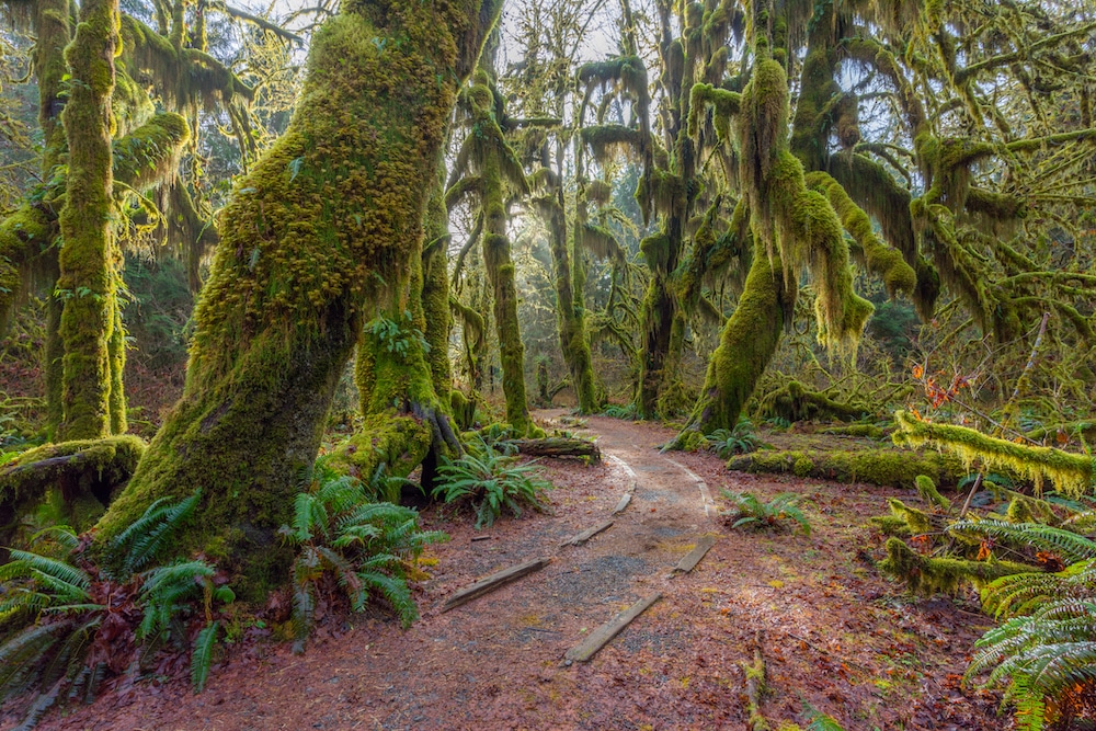
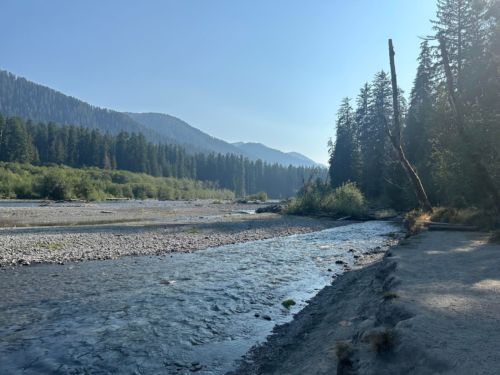
Named for the Hoh River that runs from Mount Olympus to the Pacific Coast, the Hoh Rainforest is one of the largest temperate rainforests in the United States. This magical ecosystem is one of the wettest places in the country, with an annual average rainfall of 140 inches per year. All that rain creates a dense canopy of deciduous and coniferous trees, and the forest floor is blanketed with ferns, fungi and mosses.
A gigantic rainforest once stretched from southeastern Alaska all the way to central California along the Pacific Coast — the Hoh Rainforest is what remains of that ancient forest.
Located around an hour drive from the city of Forks, Washington, and a two-hour drive or so from Port Angeles, the Hoh Rainforest is in the western portion of Olympic National Park. To get there take Highway 101 to Upper Hoh Road.
The old-growth forest has a year-round campground with 72 sites along the Hoh River. Reservations can be made six months in advance at recreation.gov.
Stop in at the Hoh Rain Forest Visitor Center — closed from January through early March — for tips on making the most of your visit.
From the visitor center there are two loop trails: the 0.8-mile Hall of Mosses Trail — which features old-growth forest, including a maple tree grove and club moss springing from the forest floor — and the 1.2-mile Spruce Nature Trail, which leads you along the Hoh River and Taft Creek through new- and old-growth forest.
The main hiking trail in the Hoh Rainforest is the out-and-back Hoh River Trail. You can take this trail as far as you feel comfortable, up to its endpoint 18.5 miles in. Along the way the trail takes you past multiple campsites, the farthest of which is Glacier Meadows at 17.3 miles in. The trail ends with a view of Mt. Olympus at Blue Glacier moraine.
“I love the Hoh Rainforest! The Hoh River trail parallels the Hoh River and is relatively easy. At the end of August, the river is low enough that you can wade across it near Tom Creek,” adventurer Sarah Strock told EcoWatch.
The Hoh Rainforest. Sarah Strock
Just past the ranger station on the Hoh River Trail is the Hoh Lake Trail, which goes up to Bogachiel Peak between the Sol Duc Valley and the rainforest. Turn-around day hikes in this area include Mineral Creek Falls 2.7 miles in; First River access 0.9 miles in; Cedar Grove four miles in; and Five-Mile Island, which is five miles one way.
More information on hiking and permits for the Hoh River Trail and Olympic National Park can be found on the Wilderness Backpacking Reservations page. Pets are not permitted on Hoh Rainforest trails.
With the Hoh’s plentiful rainfall comes a rich ecosystem of flora and fauna. Average summer temperatures stay in the pleasant mid-70 degrees Fahrenheit, and the dense forest canopy and thick undergrowth provide ample shade for the rainforest’s many species.
Mammals like black bears, Roosevelt elk and river otters are common. Mountain lions and bobcats can be harder to spot, but at night you may hear or feel them roaming about their mystical home. Making their way along the forest floor are snails, banana slugs, salamanders, snakes and rodents. Songs, screeches and hoots from barred owls, American robins and Canada grey jay can frequently be heard, along with sightings of these majestic creatures. The endangered northern spotted owl also graces the old-growth trees of the forest.
Among the mammoth trees you will spot in the Hoh Rainforest are red cedar, sitka spruce, douglas fir and big leaf maple. As you explore the rainforest, you will see many fallen trees. When one of these giants topples, it allows sunlight onto the floor of the forest and provides nutrients for many new plants, animals and fungi.
There is truly no place like the ancient, hushed wonderland of the Hoh Rainforest — living evidence of the height of our planet’s balance and beauty.
Painted Hills, Central Oregon
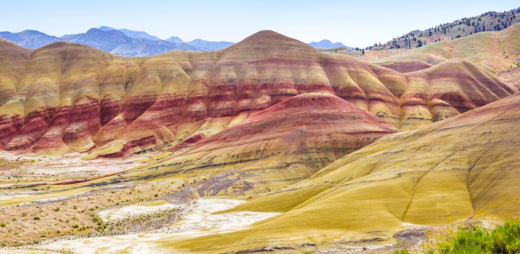
The red and gold Painted Hills of Central Oregon sit like colorful camel humps in the foreground of the Cascade Mountain Range. The soft, rolling hills were formed 32 to 35 million years ago by sedimented clay and cooled and oxidized ash from the nearby mountains.
“If you drive north past the Painted Hills, the road will become thin and rutted. It passes through the John Day river canyon, with views normally available only to the ranchers and farmers who line its banks. It comes out on the crest of the Ochoco Mountains near Antelope, in a location where you can watch the sun set behind the Cascades – spanning from Rainier to South Sister,” lifelong Oregon resident Zach Spier told EcoWatch.
The climate east and west of the Cascades is vastly different. The western part of Oregon is temperate and rainy, while in the east lies the dry and cooler high desert.
To the east of the mountains is the John Day Fossil Beds National Monument. The monument is made up of three units — including the Painted Hills — each from one to two hours apart by car. The formation of the varying strata of the fossil beds began approximately 100 million years ago; it continues to this day.
Located about 10 miles from the town of Mitchell, the Painted Hills are located within the John Day River Basin. The ash that gives the hills some of their layers blew east from the mountains, and combined with shale and clay deposits to give the hills their colorful stripes.
“The reddish and yellowish layers consist of laterites, soils rich in iron and aluminum that were created in tropical climates with a distinct wet and dry season. Red soils come from a more tropical period, while the yellows are from a drier and cooler time. Dark black dots and streaks in the hills are stains from manganese nodules, likely the work of plants that fixed the mineral or from salts that became concentrated as pools of water rich in the mineral dried up,” the Geology In website explains.
There are five hiking trails in the Painted Hills unit, each with its own parking area along Bear Creek Road. They include the 0.5-mile Painted Hills Overlook Trail, the 1.6-mile Carroll Rim Trail, the 0.25-mile Painted Cove Trail, the 0.25-mile Red Scar Knoll Trail and the 0.25-mile Leaf Hill Trail.
Learn more about the region’s geological history at the Thomas Condon Visitor Center, located in the Sheep Rock unit of the John Day Fossil Beds National Monument. The visitor center has a paleontology lab, fossil gallery and displays with information on the more than 40-million-year-old fossil record of the area. The center also offers a short film, Layers of Life: Stories of Ancient Oregon.
Oregon Dunes National Recreation Area
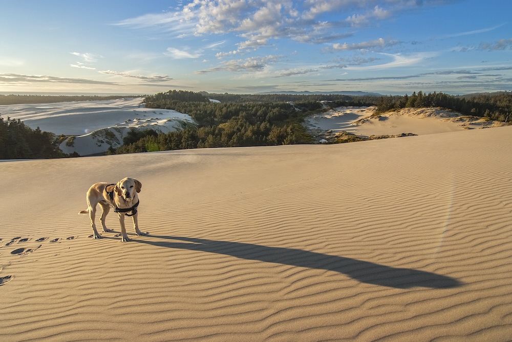
While exploring the Pacific Northwest, the rugged and dynamic Oregon Coast is a place you won’t want to miss! Among its wonders is the Oregon Dunes National Recreation Area — one of the most extensive temperate coastal sand dunes on Earth. Looking out upon the expanse of undulating golden sand, you might feel as though you’ve traveled to the Sahara Desert.
Part of the Siuslaw National Forest, the 31,500-acre Oregon Dunes were designated as a National Recreation Area in 1972. The sand in the dunes comes from sedimentary rock, uplifted and blown over from the Oregon Coast Mountain Range 12 million years ago. The rock moved downstream in rivers, eroding into sand. The shoreline as it stands now stabilized 6,000 years ago, but wind and water shape the dunes into various formations that change throughout the year.
The unique ecosystem of ocean, forest and dunes is home to many animal and plant species, including the western snowy plover — tiny shore birds who lay their eggs on the open sand; black-tailed deer — a subspecies of mule deer who sometimes graze on foredune grasses near the beach; bald eagles, raptors and golden eagles, who can be seen soaring above the dunes in the warm summer months; bobcats who roam the dunes at night, hunting birds and small mammals living in small stands of trees; the rare Humboldt marten, who usually lives in old-growth forests along the coast, but ecosystem changes have caused to take up residence in sand dune forests; sand verbena — a sweet-smelling succulent with bright yellow and pink flowers; tiny coastal strawberries that ripen into a rare and delicious treat in late June; and European beachgrass — an invasive species introduced in the early 1900s to keep the dunes from overtaking railroads, roads and ports, but which now covers more than half the landscape and threatens all of it.
There are several trails to guide you through the varied landscapes of the Oregon Dunes. One of them is the Tahkenitch Dunes Trail near Gardiner, Oregon. This six-mile loop takes about two-and-a-half hours, offers opportunities for birdwatching and does not allow dogs.
“The Tahkenitch Dunes trail is a quiet respite, taking hikers in a loop through multiple ecosystems, including areas in the process of becoming forested,” Spier told EcoWatch.
A shorter hike that you can take with your canine best pal is the 1.4-mile Tahkenitch Creek Trail, which is also a loop that takes about half an hour to complete.
Another possibility is the Oregon Dunes Loop Trail — a four-mile, moderately challenging hike near Westlake, Oregon. It takes about an hour and 17 minutes and does not allow dogs.
If you’re looking to gain some elevation and see a body of water other than the magnificent Pacific Ocean, the Threemile Lake Trail might be for you. This out-and-back hike is a total of 6.1 miles and takes you 997 feet above sea level to Threemile Lake. Starting out near Gardiner, the moderately challenging route takes about two hours and 47 minutes and is best tackled from March through October.
The distinctive colors, textures, animals and plants of the wind-blown Oregon Sand Dunes pretty much guarantee that whatever you choose to do while visiting this one-of-a-kind landscape, your experience will be unforgettable.
Columbia River Gorge National Scenic Area, Border of Washington and Oregon
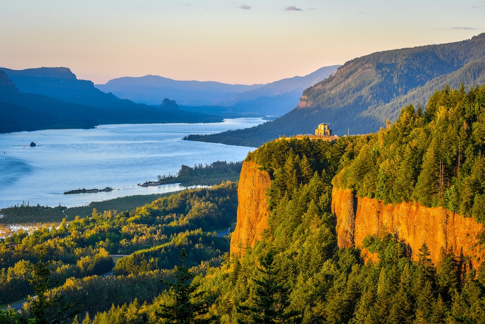
A trip to the Pacific Northwest would not be complete without a visit to the Columbia River Gorge. The gorge is an 80-mile-long, meandering spectacle of ridges, overlooks, cliffs and waterfalls. At 1,243 miles long, the Columbia River is the biggest river in the Pacific Northwest and forms the border of Oregon and Washington.
“I have ridden my motorcycle many times through the Columbia River Gorge area on both sides of the river, Highway 84 in Oregon or 14 in Washington, and both offer spectacular views going both directions of the marvelous geology and wondrous architecture of Mother Nature,” Harley rider and nature enthusiast Patrick Roat told EcoWatch.
The country’s largest national scenic area was formed approximately 18,000 years ago when an ice dam broke and Lake Missoula flooded the region on its way to the sea, forming gorges in its path.
Long before pioneers settled the gorge, the Klickitat Tribe thrived on the river’s plentiful salmon from both the Klickitat and Columbia Rivers.
The Columbia Gorge boasts the most waterfalls in the U.S., including the famous Multnomah Falls, Oregon’s tallest waterfall at 620 feet.
Hiking and camping are both popular pastimes here, as are picking your own fresh fruit at local orchards, enjoying fresh produce from nearby farms and visiting regional wineries.
Hundreds of wildlife species grace the Columbia Basin Watershed, including beavers, bobcats, black bears, the Pacific tree frog, yellow-bellied marmots, chipmunks, the western tanager, the greater roadrunner, the California ground squirrel, steelhead, walleye and small and largemouth bass.
One of the many trails you can follow through this glorious landscape is the 2.3-mile Oneonta Gorge Trail that leads you through a canyon past waterfalls and scenic views. The best time to hike this trail may be in late summer, as the canyon is at risk for flash floods in the spring. Also, stay clear of log jams.
Other hikes include the 13.1-mile out and back Eagle Creek Trail — 25.8 total miles — to Wahtum Lake; the six-mile Munra Point Trail with an elevation gain of 2,300 feet and spectacular views; and the 12-mile Tunnel Falls hike that will take you past multiple waterfalls.
Head to the Bridge of the Gods trailhead to join the Pacific Crest Trail, Section G of which leads to Timberline Lodge.
Another fun option is the Hood River Fruit Loop, a 35-mile drive through the Hood River Valley, where you will be greeted by fruit stands, u-pick farms and wineries. Depending on the season, you may find cherries, berries, lavender, apricots, flowers, pumpkins or wine and beer tastings.
“I absolutely love it in the summertime, it’s like a mini Grand Canyon in places, and it feels sort of hidden because it’s not on major highways per se like I-90 or I-5,” Roat said.
For those who love to be out on the water, the gorge provides opportunities for boating, canoeing, windsurfing and swimming, as well as kayak tours.
The Columbia River Gorge has something for everyone — each season offers new ways to appreciate this testament to the untamed splendor of the Pacific Northwest.
“The canyons, spires, cliffs, and river basin all afford breathtaking views and leave you with a sense of reverence about the area that will draw you back for more,” Roat added.
The post 4 Natural Wonders of the Pacific Northwest appeared first on EcoWatch.